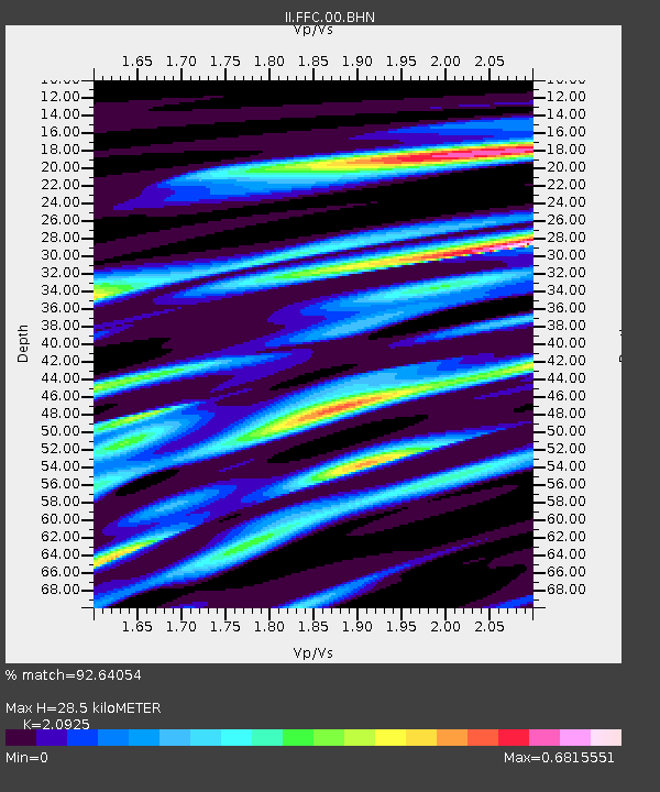
FFC Flin Flon, Canada - Earthquake Result Viewer
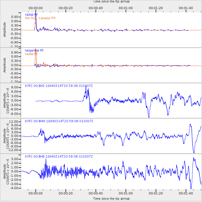
Earthquake location: Mexico-Guatemala Border Region
Earthquake latitude/longitude: 16.0/-92.4
Earthquake time(UTC): 1994/03/14 (073) 20:51:25 GMT
Earthquake Depth: 169 km
Earthquake Magnitude: 5.9 MB, 6.2 MS, 6.9 UNKNOWN, 6.2 MD
Earthquake Catalog/Contributor: WHDF/NEIC
Network: II Global Seismograph Network (GSN - IRIS/IDA)
Station: FFC Flin Flon, Canada
Lat/Lon: 54.72 N/101.98 W
Elevation: 338 m
Distance: 39.4 deg
Az: 351.251 deg
Baz: 165.392 deg
Ray Param: 0.07440326
Estimated Moho Depth: 28.5 km
Estimated Crust Vp/Vs: 2.09
Assumed Crust Vp: 6.552 km/s
Estimated Crust Vs: 3.131 km/s
Estimated Crust Poisson's Ratio: 0.35
Radial Match: 92.64054 %
Radial Bump: 283
Transverse Match: 58.33743 %
Transverse Bump: 400
SOD ConfigId: 61242
Insert Time: 2010-03-01 20:01:40.081 +0000
GWidth: 2.5
Max Bumps: 400
Tol: 0.001

Signal To Noise

ChannelStoNSTALTA
II:FFC:00:BHN:19940314T20:58:08.013007Z13.6622222.3073005E-61.688818E-7
II:FFC:00:BHE:19940314T20:58:08.013007Z4.7082226.429797E-71.3656529E-7
II:FFC:00:BHZ:19940314T20:58:08.013007Z14.883533.5862088E-62.4095152E-7
Arrivals
Ps5.1 SECOND
PpPs13 SECOND
PsPs/PpSs18 SECOND