You are here: Home > Network List > TA - USArray Transportable Network (new EarthScope stations) Stations List
> Station 121A Cookes Peak, Deming, NM, USA > Earthquake Result Viewer
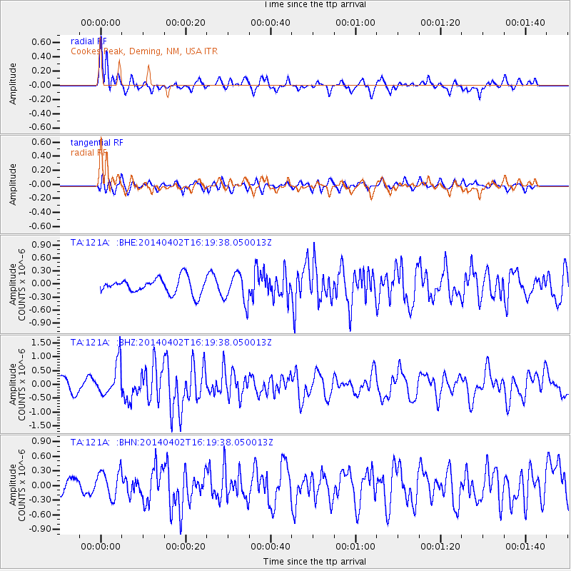
121A Cookes Peak, Deming, NM, USA - Earthquake Result Viewer
*The percent match for this event was below the threshold and hence no stack was calculated.
| Earthquake location: |
South Of Panama |
| Earthquake latitude/longitude: |
7.9/-82.3 |
| Earthquake time(UTC): |
2014/04/02 (092) 16:13:27 GMT |
| Earthquake Depth: |
32 km |
| Earthquake Magnitude: |
6.0 MWW, 5.9 MWB, 6.0 MWC |
| Earthquake Catalog/Contributor: |
NEIC PDE/NEIC COMCAT |
|
| Network: |
TA USArray Transportable Network (new EarthScope stations) |
| Station: |
121A Cookes Peak, Deming, NM, USA |
| Lat/Lon: |
32.53 N/107.79 W |
| Elevation: |
1652 m |
|
| Distance: |
34.0 deg |
| Az: |
319.575 deg |
| Baz: |
130.495 deg |
| Ray Param: |
$rayparam |
*The percent match for this event was below the threshold and hence was not used in the summary stack. |
|
| Radial Match: |
65.45552 % |
| Radial Bump: |
400 |
| Transverse Match: |
62.495953 % |
| Transverse Bump: |
400 |
| SOD ConfigId: |
626651 |
| Insert Time: |
2014-04-22 02:04:30.258 +0000 |
| GWidth: |
2.5 |
| Max Bumps: |
400 |
| Tol: |
0.001 |
|
Signal To Noise
| Channel | StoN | STA | LTA |
| TA:121A: :BHZ:20140402T16:19:38.050013Z | 3.3875968 | 6.1167134E-7 | 1.8056201E-7 |
| TA:121A: :BHN:20140402T16:19:38.050013Z | 1.6329359 | 2.8254112E-7 | 1.7302646E-7 |
| TA:121A: :BHE:20140402T16:19:38.050013Z | 1.9197851 | 3.415236E-7 | 1.7789677E-7 |
| Arrivals |
| Ps | |
| PpPs | |
| PsPs/PpSs | |


