You are here: Home > Network List > TA - USArray Transportable Network (new EarthScope stations) Stations List
> Station G59A Clarenceville, QC, USA > Earthquake Result Viewer
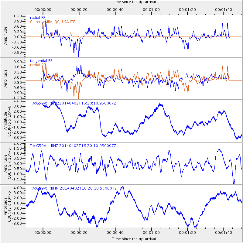
G59A Clarenceville, QC, USA - Earthquake Result Viewer
*The percent match for this event was below the threshold and hence no stack was calculated.
| Earthquake location: |
South Of Panama |
| Earthquake latitude/longitude: |
7.9/-82.3 |
| Earthquake time(UTC): |
2014/04/02 (092) 16:13:27 GMT |
| Earthquake Depth: |
32 km |
| Earthquake Magnitude: |
6.0 MWW, 5.9 MWB, 6.0 MWC |
| Earthquake Catalog/Contributor: |
NEIC PDE/NEIC COMCAT |
|
| Network: |
TA USArray Transportable Network (new EarthScope stations) |
| Station: |
G59A Clarenceville, QC, USA |
| Lat/Lon: |
45.08 N/73.18 W |
| Elevation: |
36 m |
|
| Distance: |
37.9 deg |
| Az: |
10.589 deg |
| Baz: |
194.889 deg |
| Ray Param: |
$rayparam |
*The percent match for this event was below the threshold and hence was not used in the summary stack. |
|
| Radial Match: |
48.067486 % |
| Radial Bump: |
256 |
| Transverse Match: |
39.03426 % |
| Transverse Bump: |
314 |
| SOD ConfigId: |
626651 |
| Insert Time: |
2014-04-22 02:07:09.853 +0000 |
| GWidth: |
2.5 |
| Max Bumps: |
400 |
| Tol: |
0.001 |
|
Signal To Noise
| Channel | StoN | STA | LTA |
| TA:G59A: :BHZ:20140402T16:20:10.950007Z | 1.12691 | 8.6410057E-7 | 7.667876E-7 |
| TA:G59A: :BHN:20140402T16:20:10.950007Z | 1.8100796 | 5.3798212E-6 | 2.9721464E-6 |
| TA:G59A: :BHE:20140402T16:20:10.950007Z | 1.5629116 | 2.7080903E-6 | 1.7327213E-6 |
| Arrivals |
| Ps | |
| PpPs | |
| PsPs/PpSs | |


