You are here: Home > Network List > TA - USArray Transportable Network (new EarthScope stations) Stations List
> Station H63A New Sharon, ME, USA > Earthquake Result Viewer
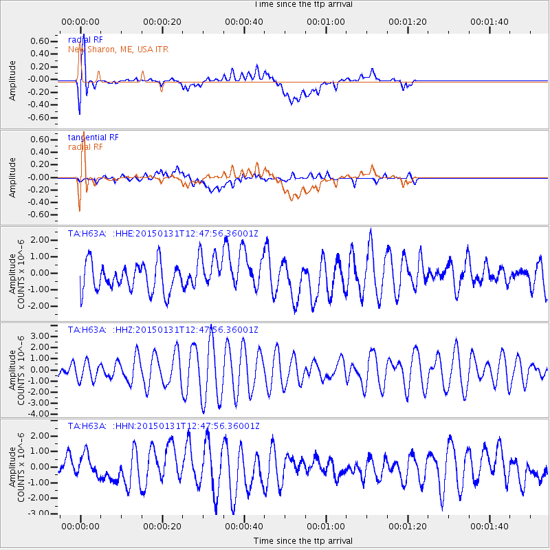
H63A New Sharon, ME, USA - Earthquake Result Viewer
*The percent match for this event was below the threshold and hence no stack was calculated.
| Earthquake location: |
Pribilof Islands, Alaska Region |
| Earthquake latitude/longitude: |
56.6/-168.9 |
| Earthquake time(UTC): |
2015/01/31 (031) 12:38:31 GMT |
| Earthquake Depth: |
8.6 km |
| Earthquake Magnitude: |
5.3 MW, 5.2 mb, 5.1 MS |
| Earthquake Catalog/Contributor: |
ISC/ISC |
|
| Network: |
TA USArray Transportable Network (new EarthScope stations) |
| Station: |
H63A New Sharon, ME, USA |
| Lat/Lon: |
44.66 N/70.04 W |
| Elevation: |
109 m |
|
| Distance: |
58.5 deg |
| Az: |
55.801 deg |
| Baz: |
320.168 deg |
| Ray Param: |
$rayparam |
*The percent match for this event was below the threshold and hence was not used in the summary stack. |
|
| Radial Match: |
76.2191 % |
| Radial Bump: |
400 |
| Transverse Match: |
50.532784 % |
| Transverse Bump: |
400 |
| SOD ConfigId: |
3390531 |
| Insert Time: |
2019-04-16 06:29:59.222 +0000 |
| GWidth: |
2.5 |
| Max Bumps: |
400 |
| Tol: |
0.001 |
|
Signal To Noise
| Channel | StoN | STA | LTA |
| TA:H63A: :HHZ:20150131T12:47:56.36001Z | 0.8055753 | 8.2145306E-7 | 1.0197099E-6 |
| TA:H63A: :HHN:20150131T12:47:56.36001Z | 0.95607394 | 7.531815E-7 | 7.8778584E-7 |
| TA:H63A: :HHE:20150131T12:47:56.36001Z | 1.3014171 | 1.0906093E-6 | 8.380167E-7 |
| Arrivals |
| Ps | |
| PpPs | |
| PsPs/PpSs | |


