You are here: Home > Network List > TA - USArray Transportable Network (new EarthScope stations) Stations List
> Station L63A North Scituate, RI, USA > Earthquake Result Viewer
L63A North Scituate, RI, USA - Earthquake Result Viewer
| Earthquake location: |
Pribilof Islands, Alaska Region |
| Earthquake latitude/longitude: |
56.6/-168.9 |
| Earthquake time(UTC): |
2015/01/31 (031) 12:38:31 GMT |
| Earthquake Depth: |
8.6 km |
| Earthquake Magnitude: |
5.3 MW, 5.2 mb, 5.1 MS |
| Earthquake Catalog/Contributor: |
ISC/ISC |
|
| Network: |
TA USArray Transportable Network (new EarthScope stations) |
| Station: |
L63A North Scituate, RI, USA |
| Lat/Lon: |
41.86 N/71.61 W |
| Elevation: |
109 m |
|
| Distance: |
59.9 deg |
| Az: |
58.908 deg |
| Baz: |
320.684 deg |
| Ray Param: |
0.061887667 |
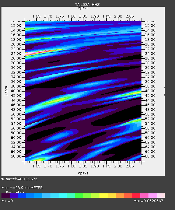
| Estimated Moho Depth: |
23.0 km |
| Estimated Crust Vp/Vs: |
1.64 |
| Assumed Crust Vp: |
6.472 km/s |
| Estimated Crust Vs: |
3.94 km/s |
| Estimated Crust Poisson's Ratio: |
0.21 |
|
| Radial Match: |
80.19676 % |
| Radial Bump: |
400 |
| Transverse Match: |
37.625984 % |
| Transverse Bump: |
400 |
| SOD ConfigId: |
3390531 |
| Insert Time: |
2019-04-16 06:30:17.319 +0000 |
| GWidth: |
2.5 |
| Max Bumps: |
400 |
| Tol: |
0.001 |
|

Signal To Noise
| Channel | StoN | STA | LTA |
| TA:L63A: :HHZ:20150131T12:48:06.199976Z | 1.3463595 | 1.6817921E-6 | 1.2491405E-6 |
| TA:L63A: :HHN:20150131T12:48:06.199976Z | 1.7403226 | 1.4346285E-6 | 8.243464E-7 |
| TA:L63A: :HHE:20150131T12:48:06.199976Z | 0.4964986 | 5.1411155E-7 | 1.0354743E-6 |
| Arrivals |
| Ps | 2.4 SECOND |
| PpPs | 8.9 SECOND |
| PsPs/PpSs | 11 SECOND |


