You are here: Home > Network List > AV - Alaska Volcano Observatory Stations List
> Station SPCR Ckakachatna River, Mount Spurr, Alaska > Earthquake Result Viewer
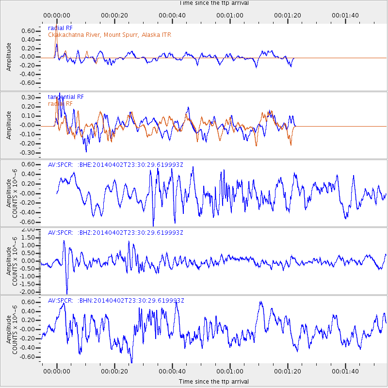
SPCR Ckakachatna River, Mount Spurr, Alaska - Earthquake Result Viewer
*The percent match for this event was below the threshold and hence no stack was calculated.
| Earthquake location: |
Eastern Honshu, Japan |
| Earthquake latitude/longitude: |
39.2/141.8 |
| Earthquake time(UTC): |
2014/04/02 (092) 23:22:47 GMT |
| Earthquake Depth: |
56 km |
| Earthquake Magnitude: |
5.6 MB, 5.5 MWC |
| Earthquake Catalog/Contributor: |
NEIC PDE/NEIC COMCAT |
|
| Network: |
AV Alaska Volcano Observatory |
| Station: |
SPCR Ckakachatna River, Mount Spurr, Alaska |
| Lat/Lon: |
61.20 N/152.21 W |
| Elevation: |
984 m |
|
| Distance: |
45.3 deg |
| Az: |
38.51 deg |
| Baz: |
272.301 deg |
| Ray Param: |
$rayparam |
*The percent match for this event was below the threshold and hence was not used in the summary stack. |
|
| Radial Match: |
53.73856 % |
| Radial Bump: |
307 |
| Transverse Match: |
60.22429 % |
| Transverse Bump: |
272 |
| SOD ConfigId: |
626651 |
| Insert Time: |
2014-04-22 02:29:00.683 +0000 |
| GWidth: |
2.5 |
| Max Bumps: |
400 |
| Tol: |
0.001 |
|
Signal To Noise
| Channel | StoN | STA | LTA |
| AV:SPCR: :BHZ:20140402T23:30:29.619993Z | 5.664175 | 7.7054244E-7 | 1.3603788E-7 |
| AV:SPCR: :BHN:20140402T23:30:29.619993Z | 1.7473559 | 3.726498E-7 | 2.1326495E-7 |
| AV:SPCR: :BHE:20140402T23:30:29.619993Z | 1.2602515 | 2.9660796E-7 | 2.3535617E-7 |
| Arrivals |
| Ps | |
| PpPs | |
| PsPs/PpSs | |


