You are here: Home > Network List > US - United States National Seismic Network Stations List
> Station HAWA Hanford, Washington, USA > Earthquake Result Viewer
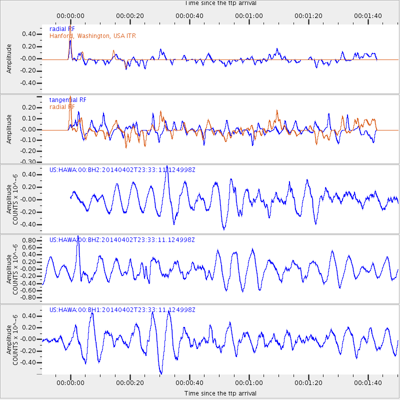
HAWA Hanford, Washington, USA - Earthquake Result Viewer
*The percent match for this event was below the threshold and hence no stack was calculated.
| Earthquake location: |
Eastern Honshu, Japan |
| Earthquake latitude/longitude: |
39.2/141.8 |
| Earthquake time(UTC): |
2014/04/02 (092) 23:22:47 GMT |
| Earthquake Depth: |
56 km |
| Earthquake Magnitude: |
5.6 MB, 5.5 MWC |
| Earthquake Catalog/Contributor: |
NEIC PDE/NEIC COMCAT |
|
| Network: |
US United States National Seismic Network |
| Station: |
HAWA Hanford, Washington, USA |
| Lat/Lon: |
46.39 N/119.53 W |
| Elevation: |
364 m |
|
| Distance: |
68.1 deg |
| Az: |
47.507 deg |
| Baz: |
304.122 deg |
| Ray Param: |
$rayparam |
*The percent match for this event was below the threshold and hence was not used in the summary stack. |
|
| Radial Match: |
38.445408 % |
| Radial Bump: |
400 |
| Transverse Match: |
57.179714 % |
| Transverse Bump: |
400 |
| SOD ConfigId: |
626651 |
| Insert Time: |
2014-04-22 03:08:56.594 +0000 |
| GWidth: |
2.5 |
| Max Bumps: |
400 |
| Tol: |
0.001 |
|
Signal To Noise
| Channel | StoN | STA | LTA |
| US:HAWA:00:BHZ:20140402T23:33:11.124998Z | 1.9202589 | 3.6362528E-7 | 1.8936262E-7 |
| US:HAWA:00:BH1:20140402T23:33:11.124998Z | 1.2820619 | 1.7341206E-7 | 1.3526028E-7 |
| US:HAWA:00:BH2:20140402T23:33:11.124998Z | 2.0417526 | 2.7511248E-7 | 1.347433E-7 |
| Arrivals |
| Ps | |
| PpPs | |
| PsPs/PpSs | |


