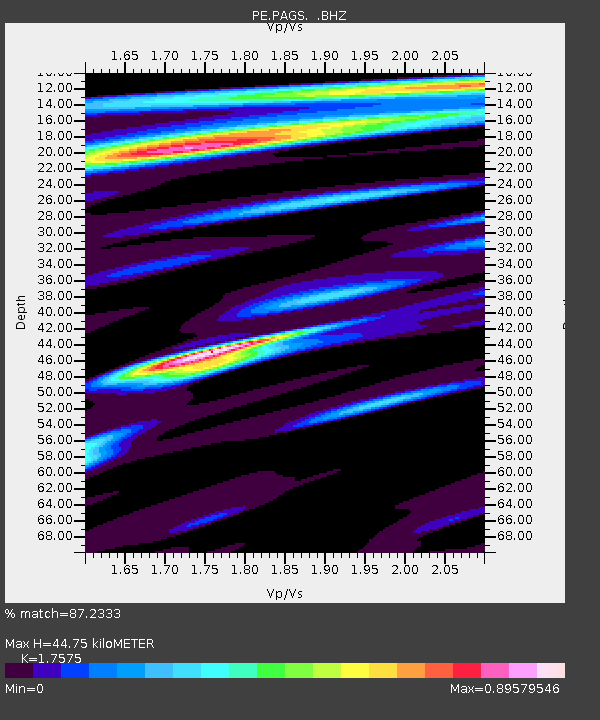
PAGS PA Geological Survey - Earthquake Result Viewer

Earthquake location: Near Coast Of Northern Chile
Earthquake latitude/longitude: -20.3/-70.6
Earthquake time(UTC): 2014/04/03 (093) 01:58:31 GMT
Earthquake Depth: 23 km
Earthquake Magnitude: 6.5 MWW, 6.5 MWB, 6.6 MWC
Earthquake Catalog/Contributor: NEIC PDE/NEIC COMCAT
Network: PE Penn State Network
Station: PAGS PA Geological Survey
Lat/Lon: 40.23 N/76.72 W
Elevation: 120 m
Distance: 60.5 deg
Az: 354.576 deg
Baz: 173.343 deg
Ray Param: 0.061490677
Estimated Moho Depth: 44.75 km
Estimated Crust Vp/Vs: 1.76
Assumed Crust Vp: 6.121 km/s
Estimated Crust Vs: 3.483 km/s
Estimated Crust Poisson's Ratio: 0.26
Radial Match: 87.2333 %
Radial Bump: 400
Transverse Match: 63.715553 %
Transverse Bump: 400
SOD ConfigId: 626651
Insert Time: 2014-04-22 03:44:04.988 +0000
GWidth: 2.5
Max Bumps: 400
Tol: 0.001

Signal To Noise

ChannelStoNSTALTA
PE:PAGS: :BHZ:20140403T02:08:08.260007Z9.5700331.1853765E-61.2386336E-7
PE:PAGS: :BHN:20140403T02:08:08.260007Z2.8963934.814751E-71.6623265E-7
PE:PAGS: :BHE:20140403T02:08:08.260007Z1.44064241.15598745E-78.0241115E-8
Arrivals
Ps5.8 SECOND
PpPs19 SECOND
PsPs/PpSs25 SECOND