You are here: Home > Network List > TA - USArray Transportable Network (new EarthScope stations) Stations List
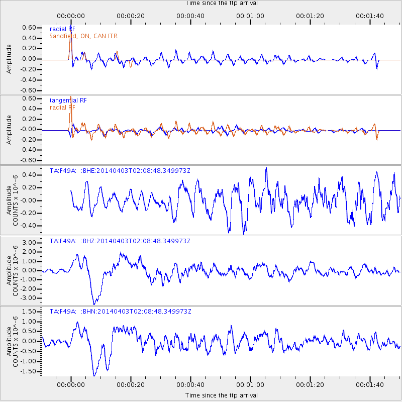
> Station F49A Sandfield, ON, CAN > Earthquake Result Viewer
F49A Sandfield, ON, CAN - Earthquake Result Viewer
| Earthquake location: |
Near Coast Of Northern Chile |
| Earthquake latitude/longitude: |
-20.3/-70.6 |
| Earthquake time(UTC): |
2014/04/03 (093) 01:58:31 GMT |
| Earthquake Depth: |
23 km |
| Earthquake Magnitude: |
6.5 MWW, 6.5 MWB, 6.6 MWC |
| Earthquake Catalog/Contributor: |
NEIC PDE/NEIC COMCAT |
|
| Network: |
TA USArray Transportable Network (new EarthScope stations) |
| Station: |
F49A Sandfield, ON, CAN |
| Lat/Lon: |
45.76 N/82.04 W |
| Elevation: |
230 m |
|
| Distance: |
66.5 deg |
| Az: |
351.259 deg |
| Baz: |
168.24 deg |
| Ray Param: |
0.05752209 |
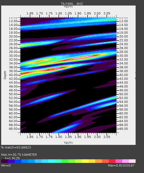
| Estimated Moho Depth: |
30.75 km |
| Estimated Crust Vp/Vs: |
1.91 |
| Assumed Crust Vp: |
6.483 km/s |
| Estimated Crust Vs: |
3.39 km/s |
| Estimated Crust Poisson's Ratio: |
0.31 |
|
| Radial Match: |
83.68623 % |
| Radial Bump: |
400 |
| Transverse Match: |
75.26369 % |
| Transverse Bump: |
400 |
| SOD ConfigId: |
626651 |
| Insert Time: |
2014-04-22 03:49:27.469 +0000 |
| GWidth: |
2.5 |
| Max Bumps: |
400 |
| Tol: |
0.001 |
|
Signal To Noise
| Channel | StoN | STA | LTA |
| TA:F49A: :BHZ:20140403T02:08:48.349973Z | 6.4677844 | 1.0825604E-6 | 1.6737732E-7 |
| TA:F49A: :BHN:20140403T02:08:48.349973Z | 2.6612346 | 5.614161E-7 | 2.1096075E-7 |
| TA:F49A: :BHE:20140403T02:08:48.349973Z | 1.2211913 | 1.4753279E-7 | 1.2081055E-7 |
| Arrivals |
| Ps | 4.5 SECOND |
| PpPs | 13 SECOND |
| PsPs/PpSs | 18 SECOND |


