You are here: Home > Network List > TA - USArray Transportable Network (new EarthScope stations) Stations List
> Station J49A Marlette, MI, USA > Earthquake Result Viewer
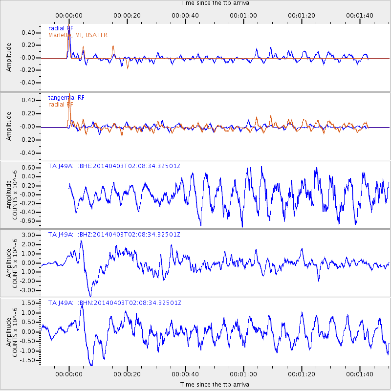
J49A Marlette, MI, USA - Earthquake Result Viewer
*The percent match for this event was below the threshold and hence no stack was calculated.
| Earthquake location: |
Near Coast Of Northern Chile |
| Earthquake latitude/longitude: |
-20.3/-70.6 |
| Earthquake time(UTC): |
2014/04/03 (093) 01:58:31 GMT |
| Earthquake Depth: |
23 km |
| Earthquake Magnitude: |
6.5 MWW, 6.5 MWB, 6.6 MWC |
| Earthquake Catalog/Contributor: |
NEIC PDE/NEIC COMCAT |
|
| Network: |
TA USArray Transportable Network (new EarthScope stations) |
| Station: |
J49A Marlette, MI, USA |
| Lat/Lon: |
43.36 N/83.14 W |
| Elevation: |
253 m |
|
| Distance: |
64.4 deg |
| Az: |
349.849 deg |
| Baz: |
166.887 deg |
| Ray Param: |
$rayparam |
*The percent match for this event was below the threshold and hence was not used in the summary stack. |
|
| Radial Match: |
62.491364 % |
| Radial Bump: |
385 |
| Transverse Match: |
45.314068 % |
| Transverse Bump: |
400 |
| SOD ConfigId: |
626651 |
| Insert Time: |
2014-04-22 03:53:39.924 +0000 |
| GWidth: |
2.5 |
| Max Bumps: |
400 |
| Tol: |
0.001 |
|
Signal To Noise
| Channel | StoN | STA | LTA |
| TA:J49A: :BHZ:20140403T02:08:34.32501Z | 5.357866 | 1.2100052E-6 | 2.2583716E-7 |
| TA:J49A: :BHN:20140403T02:08:34.32501Z | 2.725071 | 7.336401E-7 | 2.692187E-7 |
| TA:J49A: :BHE:20140403T02:08:34.32501Z | 0.6675807 | 1.0509767E-7 | 1.5743066E-7 |
| Arrivals |
| Ps | |
| PpPs | |
| PsPs/PpSs | |


