You are here: Home > Network List > TA - USArray Transportable Network (new EarthScope stations) Stations List
> Station J57A Williamstown, NY, USA > Earthquake Result Viewer
J57A Williamstown, NY, USA - Earthquake Result Viewer
| Earthquake location: |
Near Coast Of Northern Chile |
| Earthquake latitude/longitude: |
-20.3/-70.6 |
| Earthquake time(UTC): |
2014/04/03 (093) 01:58:31 GMT |
| Earthquake Depth: |
23 km |
| Earthquake Magnitude: |
6.5 MWW, 6.5 MWB, 6.6 MWC |
| Earthquake Catalog/Contributor: |
NEIC PDE/NEIC COMCAT |
|
| Network: |
TA USArray Transportable Network (new EarthScope stations) |
| Station: |
J57A Williamstown, NY, USA |
| Lat/Lon: |
43.41 N/76.00 W |
| Elevation: |
191 m |
|
| Distance: |
63.6 deg |
| Az: |
355.574 deg |
| Baz: |
174.294 deg |
| Ray Param: |
0.05947059 |
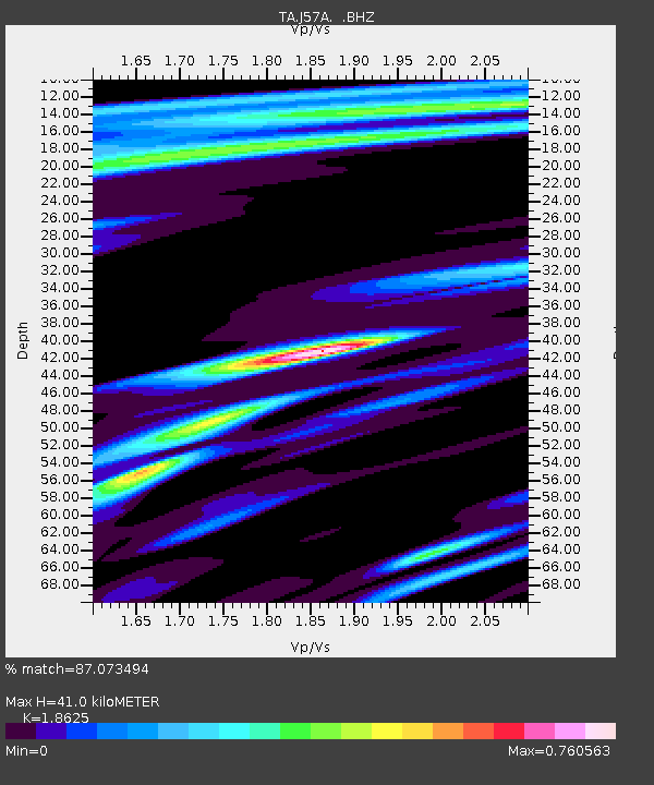
| Estimated Moho Depth: |
41.0 km |
| Estimated Crust Vp/Vs: |
1.86 |
| Assumed Crust Vp: |
6.419 km/s |
| Estimated Crust Vs: |
3.447 km/s |
| Estimated Crust Poisson's Ratio: |
0.30 |
|
| Radial Match: |
87.073494 % |
| Radial Bump: |
376 |
| Transverse Match: |
70.18754 % |
| Transverse Bump: |
400 |
| SOD ConfigId: |
626651 |
| Insert Time: |
2014-04-22 03:53:58.556 +0000 |
| GWidth: |
2.5 |
| Max Bumps: |
400 |
| Tol: |
0.001 |
|
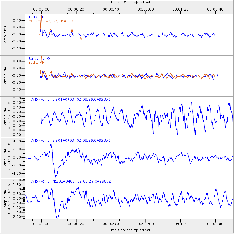
Signal To Noise
| Channel | StoN | STA | LTA |
| TA:J57A: :BHZ:20140403T02:08:29.049985Z | 3.9224682 | 9.146113E-7 | 2.331724E-7 |
| TA:J57A: :BHN:20140403T02:08:29.049985Z | 3.1349788 | 6.365225E-7 | 2.0303887E-7 |
| TA:J57A: :BHE:20140403T02:08:29.049985Z | 1.4075037 | 2.5938644E-7 | 1.8428828E-7 |
| Arrivals |
| Ps | 5.7 SECOND |
| PpPs | 18 SECOND |
| PsPs/PpSs | 23 SECOND |


