You are here: Home > Network List > TA - USArray Transportable Network (new EarthScope stations) Stations List
> Station J63A Strafford, NH, USA > Earthquake Result Viewer
J63A Strafford, NH, USA - Earthquake Result Viewer
| Earthquake location: |
Near Coast Of Northern Chile |
| Earthquake latitude/longitude: |
-20.3/-70.6 |
| Earthquake time(UTC): |
2014/04/03 (093) 01:58:31 GMT |
| Earthquake Depth: |
23 km |
| Earthquake Magnitude: |
6.5 MWW, 6.5 MWB, 6.6 MWC |
| Earthquake Catalog/Contributor: |
NEIC PDE/NEIC COMCAT |
|
| Network: |
TA USArray Transportable Network (new EarthScope stations) |
| Station: |
J63A Strafford, NH, USA |
| Lat/Lon: |
43.28 N/71.08 W |
| Elevation: |
142 m |
|
| Distance: |
63.2 deg |
| Az: |
359.573 deg |
| Baz: |
179.451 deg |
| Ray Param: |
0.059681725 |
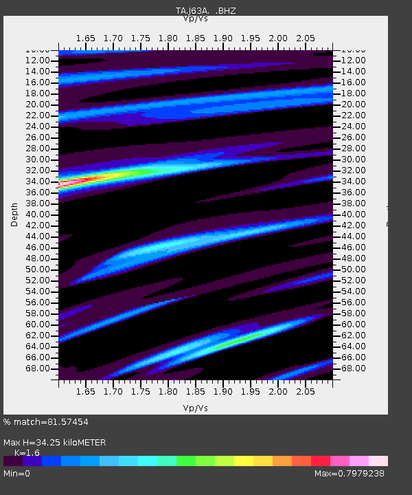
| Estimated Moho Depth: |
34.25 km |
| Estimated Crust Vp/Vs: |
1.60 |
| Assumed Crust Vp: |
6.419 km/s |
| Estimated Crust Vs: |
4.012 km/s |
| Estimated Crust Poisson's Ratio: |
0.18 |
|
| Radial Match: |
81.57454 % |
| Radial Bump: |
400 |
| Transverse Match: |
53.751507 % |
| Transverse Bump: |
400 |
| SOD ConfigId: |
626651 |
| Insert Time: |
2014-04-22 03:54:18.729 +0000 |
| GWidth: |
2.5 |
| Max Bumps: |
400 |
| Tol: |
0.001 |
|

Signal To Noise
| Channel | StoN | STA | LTA |
| TA:J63A: :BHZ:20140403T02:08:26.900022Z | 3.7017996 | 1.284468E-6 | 3.4698476E-7 |
| TA:J63A: :BHN:20140403T02:08:26.900022Z | 2.6286643 | 6.460263E-7 | 2.457622E-7 |
| TA:J63A: :BHE:20140403T02:08:26.900022Z | 0.62423575 | 2.0332325E-7 | 3.257155E-7 |
| Arrivals |
| Ps | 3.4 SECOND |
| PpPs | 13 SECOND |
| PsPs/PpSs | 17 SECOND |


