You are here: Home > Network List > TA - USArray Transportable Network (new EarthScope stations) Stations List
> Station K48A Perry, MI, USA > Earthquake Result Viewer
K48A Perry, MI, USA - Earthquake Result Viewer

| Earthquake location: |
Near Coast Of Northern Chile |
| Earthquake latitude/longitude: |
-20.3/-70.6 |
| Earthquake time(UTC): |
2014/04/03 (093) 01:58:31 GMT |
| Earthquake Depth: |
23 km |
| Earthquake Magnitude: |
6.5 MWW, 6.5 MWB, 6.6 MWC |
| Earthquake Catalog/Contributor: |
NEIC PDE/NEIC COMCAT |
|
| Network: |
TA USArray Transportable Network (new EarthScope stations) |
| Station: |
K48A Perry, MI, USA |
| Lat/Lon: |
42.80 N/84.12 W |
| Elevation: |
273 m |
|
| Distance: |
64.0 deg |
| Az: |
348.927 deg |
| Baz: |
165.818 deg |
| Ray Param: |
0.059186123 |
| Estimated Moho Depth: |
19.25 km |
| Estimated Crust Vp/Vs: |
1.79 |
| Assumed Crust Vp: |
6.483 km/s |
| Estimated Crust Vs: |
3.617 km/s |
| Estimated Crust Poisson's Ratio: |
0.27 |
|
| Radial Match: |
80.06638 % |
| Radial Bump: |
400 |
| Transverse Match: |
49.30115 % |
| Transverse Bump: |
400 |
| SOD ConfigId: |
626651 |
| Insert Time: |
2014-04-22 03:54:37.708 +0000 |
| GWidth: |
2.5 |
| Max Bumps: |
400 |
| Tol: |
0.001 |
|
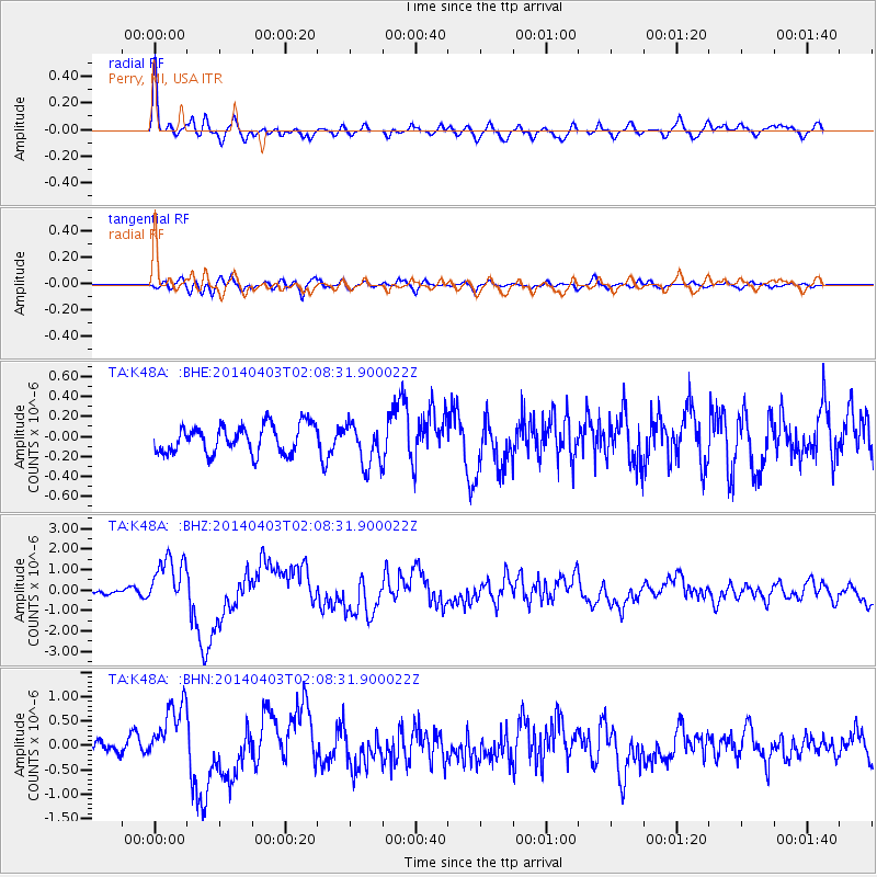
Signal To Noise
| Channel | StoN | STA | LTA |
| TA:K48A: :BHZ:20140403T02:08:31.900022Z | 6.630462 | 1.2079224E-6 | 1.8217771E-7 |
| TA:K48A: :BHN:20140403T02:08:31.900022Z | 4.3747416 | 6.246274E-7 | 1.4278041E-7 |
| TA:K48A: :BHE:20140403T02:08:31.900022Z | 1.5089043 | 2.113576E-7 | 1.4007357E-7 |
| Arrivals |
| Ps | 2.5 SECOND |
| PpPs | 7.9 SECOND |
| PsPs/PpSs | 10 SECOND |


