You are here: Home > Network List > TA - USArray Transportable Network (new EarthScope stations) Stations List
> Station K49A Clarkson, MI, USA > Earthquake Result Viewer
K49A Clarkson, MI, USA - Earthquake Result Viewer
| Earthquake location: |
Near Coast Of Northern Chile |
| Earthquake latitude/longitude: |
-20.3/-70.6 |
| Earthquake time(UTC): |
2014/04/03 (093) 01:58:31 GMT |
| Earthquake Depth: |
23 km |
| Earthquake Magnitude: |
6.5 MWW, 6.5 MWB, 6.6 MWC |
| Earthquake Catalog/Contributor: |
NEIC PDE/NEIC COMCAT |
|
| Network: |
TA USArray Transportable Network (new EarthScope stations) |
| Station: |
K49A Clarkson, MI, USA |
| Lat/Lon: |
42.78 N/83.46 W |
| Elevation: |
336 m |
|
| Distance: |
63.9 deg |
| Az: |
349.45 deg |
| Baz: |
166.498 deg |
| Ray Param: |
0.05927634 |
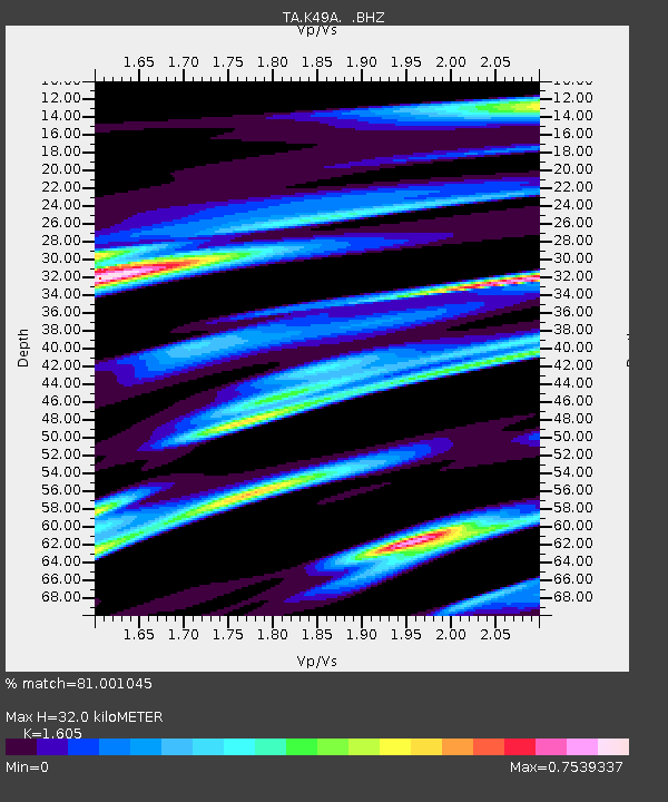
| Estimated Moho Depth: |
32.0 km |
| Estimated Crust Vp/Vs: |
1.61 |
| Assumed Crust Vp: |
6.483 km/s |
| Estimated Crust Vs: |
4.039 km/s |
| Estimated Crust Poisson's Ratio: |
0.18 |
|
| Radial Match: |
81.001045 % |
| Radial Bump: |
400 |
| Transverse Match: |
46.494576 % |
| Transverse Bump: |
400 |
| SOD ConfigId: |
626651 |
| Insert Time: |
2014-04-22 03:54:40.022 +0000 |
| GWidth: |
2.5 |
| Max Bumps: |
400 |
| Tol: |
0.001 |
|

Signal To Noise
| Channel | StoN | STA | LTA |
| TA:K49A: :BHZ:20140403T02:08:30.999998Z | 5.7376785 | 1.1201479E-6 | 1.9522668E-7 |
| TA:K49A: :BHN:20140403T02:08:30.999998Z | 2.5772977 | 6.4242306E-7 | 2.4926226E-7 |
| TA:K49A: :BHE:20140403T02:08:30.999998Z | 0.58498055 | 2.1860694E-7 | 3.7369952E-7 |
| Arrivals |
| Ps | 3.1 SECOND |
| PpPs | 12 SECOND |
| PsPs/PpSs | 15 SECOND |


