You are here: Home > Network List > TA - USArray Transportable Network (new EarthScope stations) Stations List
> Station M52A Chesterland, OH, USA > Earthquake Result Viewer
M52A Chesterland, OH, USA - Earthquake Result Viewer
| Earthquake location: |
Near Coast Of Northern Chile |
| Earthquake latitude/longitude: |
-20.3/-70.6 |
| Earthquake time(UTC): |
2014/04/03 (093) 01:58:31 GMT |
| Earthquake Depth: |
23 km |
| Earthquake Magnitude: |
6.5 MWW, 6.5 MWB, 6.6 MWC |
| Earthquake Catalog/Contributor: |
NEIC PDE/NEIC COMCAT |
|
| Network: |
TA USArray Transportable Network (new EarthScope stations) |
| Station: |
M52A Chesterland, OH, USA |
| Lat/Lon: |
41.54 N/81.36 W |
| Elevation: |
382 m |
|
| Distance: |
62.3 deg |
| Az: |
350.858 deg |
| Baz: |
168.539 deg |
| Ray Param: |
0.060285542 |
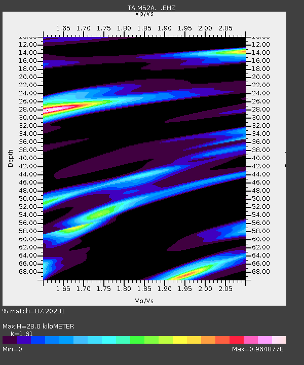
| Estimated Moho Depth: |
28.0 km |
| Estimated Crust Vp/Vs: |
1.61 |
| Assumed Crust Vp: |
6.483 km/s |
| Estimated Crust Vs: |
4.026 km/s |
| Estimated Crust Poisson's Ratio: |
0.19 |
|
| Radial Match: |
87.20281 % |
| Radial Bump: |
400 |
| Transverse Match: |
59.447113 % |
| Transverse Bump: |
400 |
| SOD ConfigId: |
626651 |
| Insert Time: |
2014-04-22 03:57:18.012 +0000 |
| GWidth: |
2.5 |
| Max Bumps: |
400 |
| Tol: |
0.001 |
|
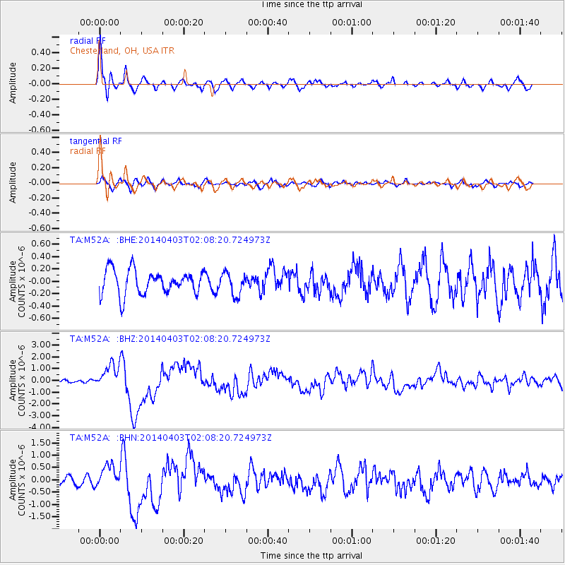
Signal To Noise
| Channel | StoN | STA | LTA |
| TA:M52A: :BHZ:20140403T02:08:20.724973Z | 6.378132 | 1.0657471E-6 | 1.6709393E-7 |
| TA:M52A: :BHN:20140403T02:08:20.724973Z | 2.4775865 | 4.5257113E-7 | 1.8266611E-7 |
| TA:M52A: :BHE:20140403T02:08:20.724973Z | 0.96264356 | 1.8832428E-7 | 1.9563242E-7 |
| Arrivals |
| Ps | 2.8 SECOND |
| PpPs | 11 SECOND |
| PsPs/PpSs | 13 SECOND |


