You are here: Home > Network List > TA - USArray Transportable Network (new EarthScope stations) Stations List
> Station N62A Caumsett State Park, Huntington, NY, USA > Earthquake Result Viewer
N62A Caumsett State Park, Huntington, NY, USA - Earthquake Result Viewer
| Earthquake location: |
Near Coast Of Northern Chile |
| Earthquake latitude/longitude: |
-20.3/-70.6 |
| Earthquake time(UTC): |
2014/04/03 (093) 01:58:31 GMT |
| Earthquake Depth: |
23 km |
| Earthquake Magnitude: |
6.5 MWW, 6.5 MWB, 6.6 MWC |
| Earthquake Catalog/Contributor: |
NEIC PDE/NEIC COMCAT |
|
| Network: |
TA USArray Transportable Network (new EarthScope stations) |
| Station: |
N62A Caumsett State Park, Huntington, NY, USA |
| Lat/Lon: |
40.93 N/73.47 W |
| Elevation: |
34 m |
|
| Distance: |
60.9 deg |
| Az: |
357.476 deg |
| Baz: |
176.872 deg |
| Ray Param: |
0.06116768 |
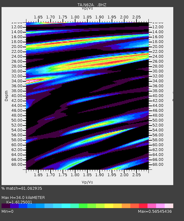
| Estimated Moho Depth: |
34.0 km |
| Estimated Crust Vp/Vs: |
1.61 |
| Assumed Crust Vp: |
6.472 km/s |
| Estimated Crust Vs: |
4.014 km/s |
| Estimated Crust Poisson's Ratio: |
0.19 |
|
| Radial Match: |
81.062935 % |
| Radial Bump: |
400 |
| Transverse Match: |
51.45753 % |
| Transverse Bump: |
400 |
| SOD ConfigId: |
626651 |
| Insert Time: |
2014-04-22 03:59:30.434 +0000 |
| GWidth: |
2.5 |
| Max Bumps: |
400 |
| Tol: |
0.001 |
|

Signal To Noise
| Channel | StoN | STA | LTA |
| TA:N62A: :BHZ:20140403T02:08:11.57501Z | 4.481713 | 1.0997976E-6 | 2.453967E-7 |
| TA:N62A: :BHN:20140403T02:08:11.57501Z | 3.0321856 | 6.9481854E-7 | 2.2914777E-7 |
| TA:N62A: :BHE:20140403T02:08:11.57501Z | 1.0975943 | 2.4627997E-7 | 2.2438162E-7 |
| Arrivals |
| Ps | 3.4 SECOND |
| PpPs | 13 SECOND |
| PsPs/PpSs | 16 SECOND |


