You are here: Home > Network List > TA - USArray Transportable Network (new EarthScope stations) Stations List
> Station Q50A Georgetown, OH, USA > Earthquake Result Viewer
Q50A Georgetown, OH, USA - Earthquake Result Viewer
| Earthquake location: |
Near Coast Of Northern Chile |
| Earthquake latitude/longitude: |
-20.3/-70.6 |
| Earthquake time(UTC): |
2014/04/03 (093) 01:58:31 GMT |
| Earthquake Depth: |
23 km |
| Earthquake Magnitude: |
6.5 MWW, 6.5 MWB, 6.6 MWC |
| Earthquake Catalog/Contributor: |
NEIC PDE/NEIC COMCAT |
|
| Network: |
TA USArray Transportable Network (new EarthScope stations) |
| Station: |
Q50A Georgetown, OH, USA |
| Lat/Lon: |
38.84 N/83.98 W |
| Elevation: |
262 m |
|
| Distance: |
60.1 deg |
| Az: |
347.933 deg |
| Baz: |
165.444 deg |
| Ray Param: |
0.061704665 |
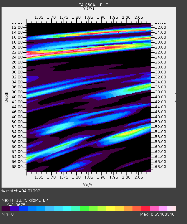
| Estimated Moho Depth: |
13.75 km |
| Estimated Crust Vp/Vs: |
1.97 |
| Assumed Crust Vp: |
6.232 km/s |
| Estimated Crust Vs: |
3.167 km/s |
| Estimated Crust Poisson's Ratio: |
0.33 |
|
| Radial Match: |
84.81092 % |
| Radial Bump: |
341 |
| Transverse Match: |
54.798775 % |
| Transverse Bump: |
400 |
| SOD ConfigId: |
626651 |
| Insert Time: |
2014-04-22 04:01:54.833 +0000 |
| GWidth: |
2.5 |
| Max Bumps: |
400 |
| Tol: |
0.001 |
|
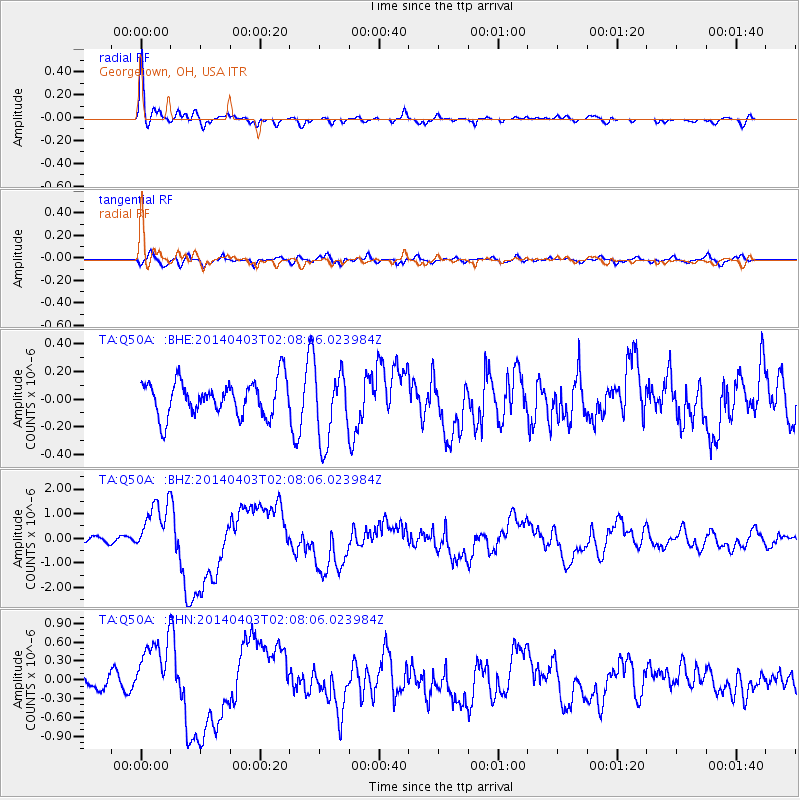
Signal To Noise
| Channel | StoN | STA | LTA |
| TA:Q50A: :BHZ:20140403T02:08:06.023984Z | 8.258512 | 1.0867209E-6 | 1.31588E-7 |
| TA:Q50A: :BHN:20140403T02:08:06.023984Z | 3.2542093 | 5.141943E-7 | 1.58009E-7 |
| TA:Q50A: :BHE:20140403T02:08:06.023984Z | 2.079153 | 2.615145E-7 | 1.2577932E-7 |
| Arrivals |
| Ps | 2.2 SECOND |
| PpPs | 6.3 SECOND |
| PsPs/PpSs | 8.5 SECOND |


