You are here: Home > Network List > II - Global Seismograph Network (GSN - IRIS/IDA) Stations List
> Station FFC Flin Flon, Canada > Earthquake Result Viewer
FFC Flin Flon, Canada - Earthquake Result Viewer
| Earthquake location: |
Mariana Islands |
| Earthquake latitude/longitude: |
18.9/145.4 |
| Earthquake time(UTC): |
2007/10/31 (304) 03:30:17 GMT |
| Earthquake Depth: |
223 km |
| Earthquake Magnitude: |
6.2 MB, 7.2 MW, 7.2 MW |
| Earthquake Catalog/Contributor: |
WHDF/NEIC |
|
| Network: |
II Global Seismograph Network (GSN - IRIS/IDA) |
| Station: |
FFC Flin Flon, Canada |
| Lat/Lon: |
54.72 N/101.98 W |
| Elevation: |
338 m |
|
| Distance: |
87.1 deg |
| Az: |
32.412 deg |
| Baz: |
298.977 deg |
| Ray Param: |
0.043045018 |
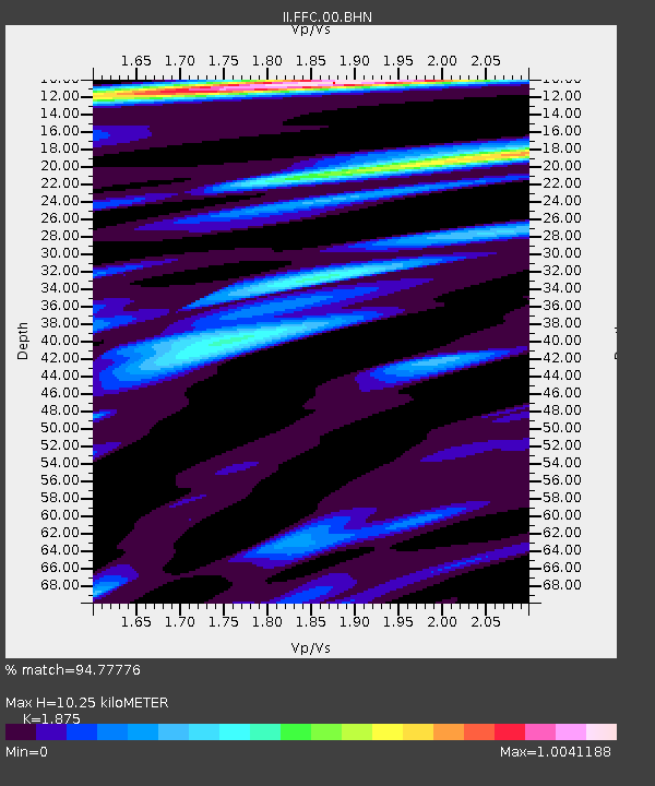
| Estimated Moho Depth: |
10.25 km |
| Estimated Crust Vp/Vs: |
1.88 |
| Assumed Crust Vp: |
6.552 km/s |
| Estimated Crust Vs: |
3.495 km/s |
| Estimated Crust Poisson's Ratio: |
0.30 |
|
| Radial Match: |
94.77776 % |
| Radial Bump: |
347 |
| Transverse Match: |
84.76106 % |
| Transverse Bump: |
400 |
| SOD ConfigId: |
2564 |
| Insert Time: |
2010-03-01 20:07:06.721 +0000 |
| GWidth: |
2.5 |
| Max Bumps: |
400 |
| Tol: |
0.001 |
|
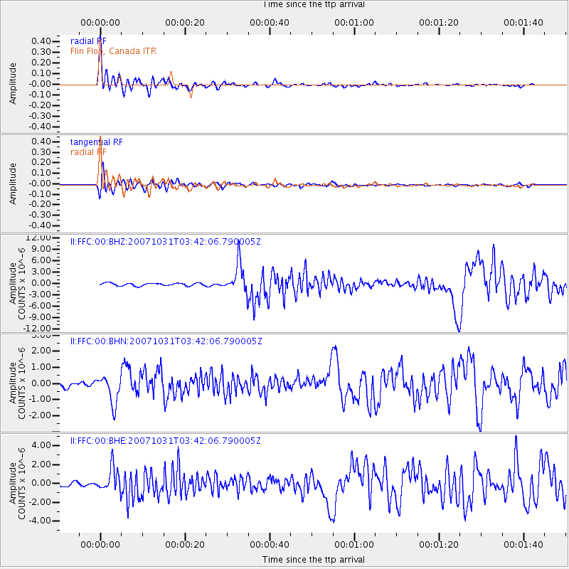
Signal To Noise
| Channel | StoN | STA | LTA |
| II:FFC:00:BHN:20071031T03:42:06.790005Z | 3.405015 | 9.106452E-7 | 2.6744235E-7 |
| II:FFC:00:BHE:20071031T03:42:06.790005Z | 3.811531 | 1.2976313E-6 | 3.4044885E-7 |
| II:FFC:00:BHZ:20071031T03:42:06.790005Z | 11.524252 | 4.10185E-6 | 3.5593203E-7 |
| Arrivals |
| Ps | 1.4 SECOND |
| PpPs | 4.4 SECOND |
| PsPs/PpSs | 5.8 SECOND |


