You are here: Home > Network List > TA - USArray Transportable Network (new EarthScope stations) Stations List
> Station R57A Stanardsville, VA, USA > Earthquake Result Viewer
R57A Stanardsville, VA, USA - Earthquake Result Viewer
| Earthquake location: |
Near Coast Of Northern Chile |
| Earthquake latitude/longitude: |
-20.3/-70.6 |
| Earthquake time(UTC): |
2014/04/03 (093) 01:58:31 GMT |
| Earthquake Depth: |
23 km |
| Earthquake Magnitude: |
6.5 MWW, 6.5 MWB, 6.6 MWC |
| Earthquake Catalog/Contributor: |
NEIC PDE/NEIC COMCAT |
|
| Network: |
TA USArray Transportable Network (new EarthScope stations) |
| Station: |
R57A Stanardsville, VA, USA |
| Lat/Lon: |
38.30 N/78.52 W |
| Elevation: |
230 m |
|
| Distance: |
58.7 deg |
| Az: |
352.669 deg |
| Baz: |
171.243 deg |
| Ray Param: |
0.06262217 |
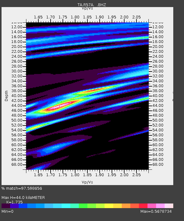
| Estimated Moho Depth: |
44.0 km |
| Estimated Crust Vp/Vs: |
1.74 |
| Assumed Crust Vp: |
6.159 km/s |
| Estimated Crust Vs: |
3.55 km/s |
| Estimated Crust Poisson's Ratio: |
0.25 |
|
| Radial Match: |
97.598656 % |
| Radial Bump: |
226 |
| Transverse Match: |
67.135956 % |
| Transverse Bump: |
400 |
| SOD ConfigId: |
626651 |
| Insert Time: |
2014-04-22 04:03:03.800 +0000 |
| GWidth: |
2.5 |
| Max Bumps: |
400 |
| Tol: |
0.001 |
|

Signal To Noise
| Channel | StoN | STA | LTA |
| TA:R57A: :BHZ:20140403T02:07:56.400022Z | 9.086692 | 1.3612204E-6 | 1.4980372E-7 |
| TA:R57A: :BHN:20140403T02:07:56.400022Z | 10.469049 | 7.552957E-7 | 7.214558E-8 |
| TA:R57A: :BHE:20140403T02:07:56.400022Z | 0.9476877 | 1.6240112E-7 | 1.7136566E-7 |
| Arrivals |
| Ps | 5.5 SECOND |
| PpPs | 19 SECOND |
| PsPs/PpSs | 24 SECOND |


