You are here: Home > Network List > TA - USArray Transportable Network (new EarthScope stations) Stations List
> Station V55A Taylorsville, NC, USA > Earthquake Result Viewer
V55A Taylorsville, NC, USA - Earthquake Result Viewer
| Earthquake location: |
Near Coast Of Northern Chile |
| Earthquake latitude/longitude: |
-20.3/-70.6 |
| Earthquake time(UTC): |
2014/04/03 (093) 01:58:31 GMT |
| Earthquake Depth: |
23 km |
| Earthquake Magnitude: |
6.5 MWW, 6.5 MWB, 6.6 MWC |
| Earthquake Catalog/Contributor: |
NEIC PDE/NEIC COMCAT |
|
| Network: |
TA USArray Transportable Network (new EarthScope stations) |
| Station: |
V55A Taylorsville, NC, USA |
| Lat/Lon: |
35.85 N/81.21 W |
| Elevation: |
306 m |
|
| Distance: |
56.7 deg |
| Az: |
349.645 deg |
| Baz: |
168.011 deg |
| Ray Param: |
0.06392656 |
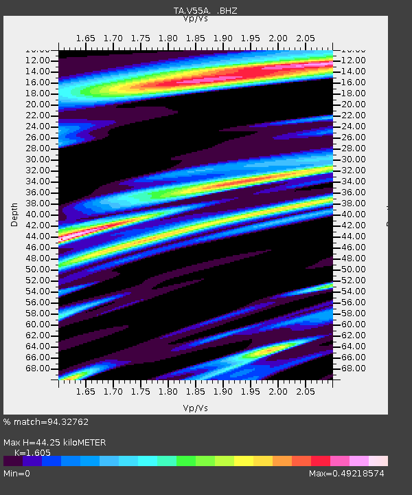
| Estimated Moho Depth: |
44.25 km |
| Estimated Crust Vp/Vs: |
1.61 |
| Assumed Crust Vp: |
6.419 km/s |
| Estimated Crust Vs: |
4.0 km/s |
| Estimated Crust Poisson's Ratio: |
0.18 |
|
| Radial Match: |
94.32762 % |
| Radial Bump: |
400 |
| Transverse Match: |
64.71364 % |
| Transverse Bump: |
400 |
| SOD ConfigId: |
626651 |
| Insert Time: |
2014-04-22 04:05:47.123 +0000 |
| GWidth: |
2.5 |
| Max Bumps: |
400 |
| Tol: |
0.001 |
|

Signal To Noise
| Channel | StoN | STA | LTA |
| TA:V55A: :BHZ:20140403T02:07:42.275022Z | 10.277782 | 1.1292884E-6 | 1.0987666E-7 |
| TA:V55A: :BHN:20140403T02:07:42.275022Z | 8.114212 | 5.919608E-7 | 7.2953576E-8 |
| TA:V55A: :BHE:20140403T02:07:42.275022Z | 1.8187661 | 1.4963406E-7 | 8.2272294E-8 |
| Arrivals |
| Ps | 4.4 SECOND |
| PpPs | 17 SECOND |
| PsPs/PpSs | 21 SECOND |


