You are here: Home > Network List > TA - USArray Transportable Network (new EarthScope stations) Stations List
> Station W41B Gary Mavity, Velonia, AR, USA > Earthquake Result Viewer
W41B Gary Mavity, Velonia, AR, USA - Earthquake Result Viewer
| Earthquake location: |
Near Coast Of Northern Chile |
| Earthquake latitude/longitude: |
-20.3/-70.6 |
| Earthquake time(UTC): |
2014/04/03 (093) 01:58:31 GMT |
| Earthquake Depth: |
23 km |
| Earthquake Magnitude: |
6.5 MWW, 6.5 MWB, 6.6 MWC |
| Earthquake Catalog/Contributor: |
NEIC PDE/NEIC COMCAT |
|
| Network: |
TA USArray Transportable Network (new EarthScope stations) |
| Station: |
W41B Gary Mavity, Velonia, AR, USA |
| Lat/Lon: |
35.17 N/92.25 W |
| Elevation: |
95 m |
|
| Distance: |
58.9 deg |
| Az: |
339.281 deg |
| Baz: |
156.081 deg |
| Ray Param: |
0.0625406 |
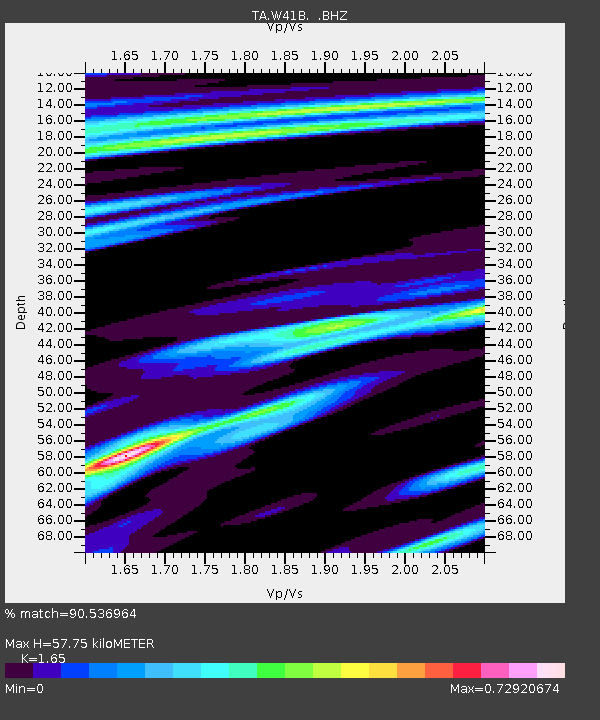
| Estimated Moho Depth: |
57.75 km |
| Estimated Crust Vp/Vs: |
1.65 |
| Assumed Crust Vp: |
6.498 km/s |
| Estimated Crust Vs: |
3.938 km/s |
| Estimated Crust Poisson's Ratio: |
0.21 |
|
| Radial Match: |
90.536964 % |
| Radial Bump: |
400 |
| Transverse Match: |
69.08034 % |
| Transverse Bump: |
400 |
| SOD ConfigId: |
626651 |
| Insert Time: |
2014-04-22 04:06:15.394 +0000 |
| GWidth: |
2.5 |
| Max Bumps: |
400 |
| Tol: |
0.001 |
|
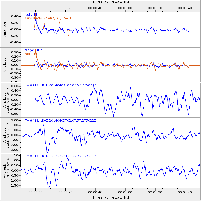
Signal To Noise
| Channel | StoN | STA | LTA |
| TA:W41B: :BHZ:20140403T02:07:57.275022Z | 5.3185177 | 7.1902235E-7 | 1.3519224E-7 |
| TA:W41B: :BHN:20140403T02:07:57.275022Z | 1.6207297 | 3.196977E-7 | 1.9725542E-7 |
| TA:W41B: :BHE:20140403T02:07:57.275022Z | 1.5758936 | 2.143022E-7 | 1.3598773E-7 |
| Arrivals |
| Ps | 6.1 SECOND |
| PpPs | 22 SECOND |
| PsPs/PpSs | 28 SECOND |


