You are here: Home > Network List > TA - USArray Transportable Network (new EarthScope stations) Stations List
> Station C06D Leavenworth, WQ, USA > Earthquake Result Viewer
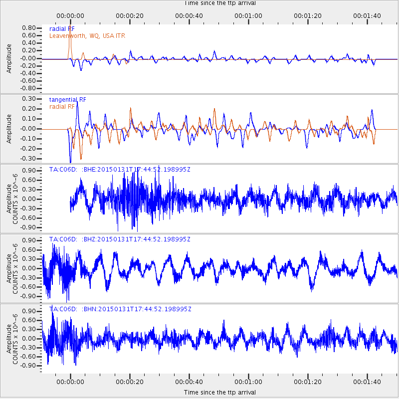
C06D Leavenworth, WQ, USA - Earthquake Result Viewer
*The percent match for this event was below the threshold and hence no stack was calculated.
| Earthquake location: |
Pribilof Islands, Alaska Region |
| Earthquake latitude/longitude: |
56.7/-169.1 |
| Earthquake time(UTC): |
2015/01/31 (031) 17:39:12 GMT |
| Earthquake Depth: |
10 km |
| Earthquake Magnitude: |
5.4 MW, 5.3 mb, 5.0 MS |
| Earthquake Catalog/Contributor: |
ISC/ISC |
|
| Network: |
TA USArray Transportable Network (new EarthScope stations) |
| Station: |
C06D Leavenworth, WQ, USA |
| Lat/Lon: |
47.92 N/120.89 W |
| Elevation: |
544 m |
|
| Distance: |
30.2 deg |
| Az: |
86.001 deg |
| Baz: |
305.009 deg |
| Ray Param: |
$rayparam |
*The percent match for this event was below the threshold and hence was not used in the summary stack. |
|
| Radial Match: |
47.86823 % |
| Radial Bump: |
400 |
| Transverse Match: |
56.23047 % |
| Transverse Bump: |
381 |
| SOD ConfigId: |
6954951 |
| Insert Time: |
2019-04-16 07:19:29.350 +0000 |
| GWidth: |
2.5 |
| Max Bumps: |
400 |
| Tol: |
0.001 |
|
Signal To Noise
| Channel | StoN | STA | LTA |
| TA:C06D: :BHZ:20150131T17:44:52.198995Z | 1.2234178 | 3.4128547E-7 | 2.789607E-7 |
| TA:C06D: :BHN:20150131T17:44:52.198995Z | 1.1569878 | 3.2357073E-7 | 2.796665E-7 |
| TA:C06D: :BHE:20150131T17:44:52.198995Z | 0.90688765 | 3.007072E-7 | 3.315815E-7 |
| Arrivals |
| Ps | |
| PpPs | |
| PsPs/PpSs | |


