You are here: Home > Network List > TA - USArray Transportable Network (new EarthScope stations) Stations List
> Station F63A Nahmakanta, Browneville, ME, USA > Earthquake Result Viewer
F63A Nahmakanta, Browneville, ME, USA - Earthquake Result Viewer
| Earthquake location: |
Pribilof Islands, Alaska Region |
| Earthquake latitude/longitude: |
56.7/-169.1 |
| Earthquake time(UTC): |
2015/01/31 (031) 17:39:12 GMT |
| Earthquake Depth: |
10 km |
| Earthquake Magnitude: |
5.4 MW, 5.3 mb, 5.0 MS |
| Earthquake Catalog/Contributor: |
ISC/ISC |
|
| Network: |
TA USArray Transportable Network (new EarthScope stations) |
| Station: |
F63A Nahmakanta, Browneville, ME, USA |
| Lat/Lon: |
45.70 N/69.10 W |
| Elevation: |
386 m |
|
| Distance: |
58.2 deg |
| Az: |
54.319 deg |
| Baz: |
320.199 deg |
| Ray Param: |
0.06302116 |
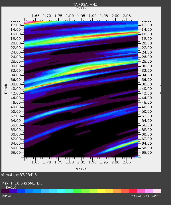
| Estimated Moho Depth: |
10.5 km |
| Estimated Crust Vp/Vs: |
1.60 |
| Assumed Crust Vp: |
6.419 km/s |
| Estimated Crust Vs: |
4.012 km/s |
| Estimated Crust Poisson's Ratio: |
0.18 |
|
| Radial Match: |
87.98415 % |
| Radial Bump: |
400 |
| Transverse Match: |
57.63067 % |
| Transverse Bump: |
400 |
| SOD ConfigId: |
6954951 |
| Insert Time: |
2019-04-16 07:20:13.349 +0000 |
| GWidth: |
2.5 |
| Max Bumps: |
400 |
| Tol: |
0.001 |
|

Signal To Noise
| Channel | StoN | STA | LTA |
| TA:F63A: :HHZ:20150131T17:48:35.369985Z | 1.0095973 | 1.3130589E-6 | 1.3005767E-6 |
| TA:F63A: :HHN:20150131T17:48:35.369985Z | 2.2352529 | 1.760807E-6 | 7.87744E-7 |
| TA:F63A: :HHE:20150131T17:48:35.369985Z | 1.242616 | 1.1269137E-6 | 9.068881E-7 |
| Arrivals |
| Ps | 1.0 SECOND |
| PpPs | 4.0 SECOND |
| PsPs/PpSs | 5.1 SECOND |


