You are here: Home > Network List > TA - USArray Transportable Network (new EarthScope stations) Stations List
> Station X43A Marvell, AR, USA > Earthquake Result Viewer
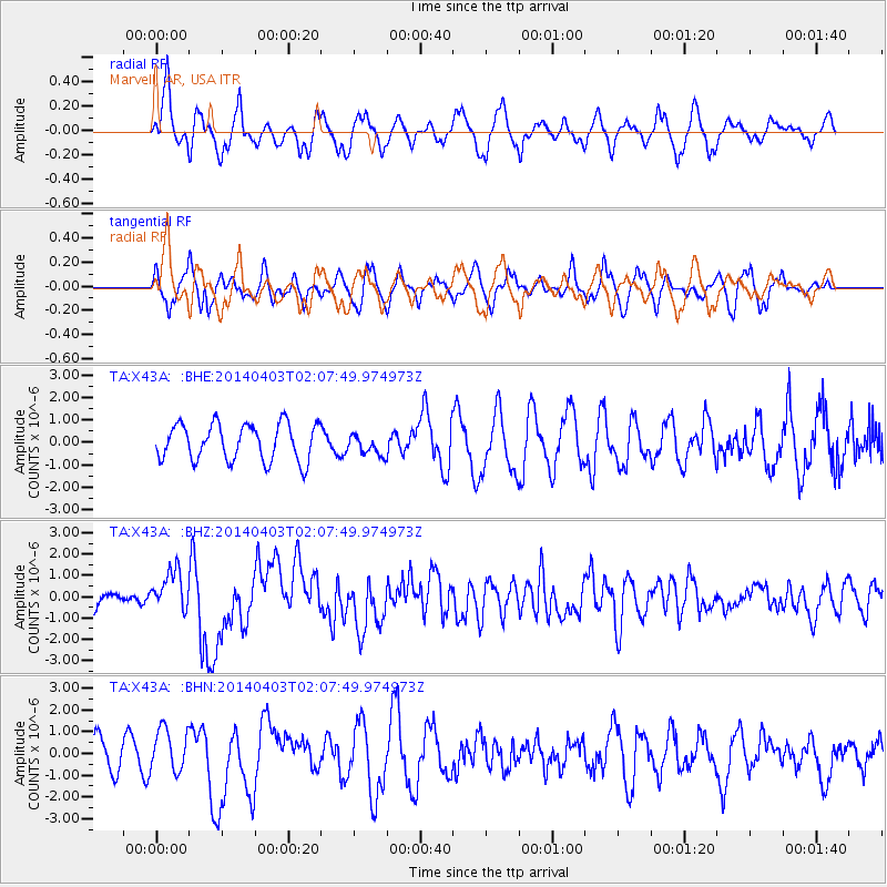
X43A Marvell, AR, USA - Earthquake Result Viewer
*The percent match for this event was below the threshold and hence no stack was calculated.
| Earthquake location: |
Near Coast Of Northern Chile |
| Earthquake latitude/longitude: |
-20.3/-70.6 |
| Earthquake time(UTC): |
2014/04/03 (093) 01:58:31 GMT |
| Earthquake Depth: |
23 km |
| Earthquake Magnitude: |
6.5 MWW, 6.5 MWB, 6.6 MWC |
| Earthquake Catalog/Contributor: |
NEIC PDE/NEIC COMCAT |
|
| Network: |
TA USArray Transportable Network (new EarthScope stations) |
| Station: |
X43A Marvell, AR, USA |
| Lat/Lon: |
34.52 N/90.88 W |
| Elevation: |
53 m |
|
| Distance: |
57.8 deg |
| Az: |
340.19 deg |
| Baz: |
157.336 deg |
| Ray Param: |
$rayparam |
*The percent match for this event was below the threshold and hence was not used in the summary stack. |
|
| Radial Match: |
68.21627 % |
| Radial Bump: |
400 |
| Transverse Match: |
62.329994 % |
| Transverse Bump: |
392 |
| SOD ConfigId: |
626651 |
| Insert Time: |
2014-04-22 04:06:41.827 +0000 |
| GWidth: |
2.5 |
| Max Bumps: |
400 |
| Tol: |
0.001 |
|
Signal To Noise
| Channel | StoN | STA | LTA |
| TA:X43A: :BHZ:20140403T02:07:49.974973Z | 2.3128622 | 9.408061E-7 | 4.0677136E-7 |
| TA:X43A: :BHN:20140403T02:07:49.974973Z | 1.1813383 | 9.631005E-7 | 8.152623E-7 |
| TA:X43A: :BHE:20140403T02:07:49.974973Z | 0.56029063 | 4.555617E-7 | 8.1308104E-7 |
| Arrivals |
| Ps | |
| PpPs | |
| PsPs/PpSs | |


