You are here: Home > Network List > TA - USArray Transportable Network (new EarthScope stations) Stations List
> Station X54A Belton, SC, USA > Earthquake Result Viewer
X54A Belton, SC, USA - Earthquake Result Viewer

| Earthquake location: |
Near Coast Of Northern Chile |
| Earthquake latitude/longitude: |
-20.3/-70.6 |
| Earthquake time(UTC): |
2014/04/03 (093) 01:58:31 GMT |
| Earthquake Depth: |
23 km |
| Earthquake Magnitude: |
6.5 MWW, 6.5 MWB, 6.6 MWC |
| Earthquake Catalog/Contributor: |
NEIC PDE/NEIC COMCAT |
|
| Network: |
TA USArray Transportable Network (new EarthScope stations) |
| Station: |
X54A Belton, SC, USA |
| Lat/Lon: |
34.55 N/82.37 W |
| Elevation: |
213 m |
|
| Distance: |
55.7 deg |
| Az: |
348.185 deg |
| Baz: |
166.534 deg |
| Ray Param: |
0.06461785 |
| Estimated Moho Depth: |
38.25 km |
| Estimated Crust Vp/Vs: |
1.76 |
| Assumed Crust Vp: |
6.35 km/s |
| Estimated Crust Vs: |
3.598 km/s |
| Estimated Crust Poisson's Ratio: |
0.26 |
|
| Radial Match: |
92.66301 % |
| Radial Bump: |
400 |
| Transverse Match: |
64.064545 % |
| Transverse Bump: |
400 |
| SOD ConfigId: |
626651 |
| Insert Time: |
2014-04-22 04:06:50.261 +0000 |
| GWidth: |
2.5 |
| Max Bumps: |
400 |
| Tol: |
0.001 |
|
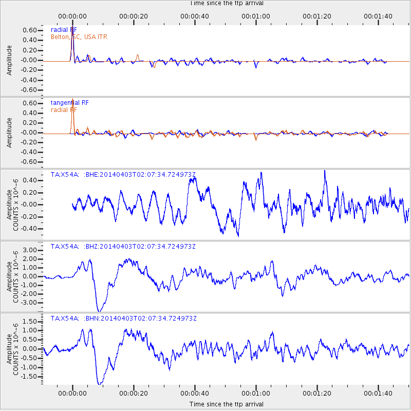
Signal To Noise
| Channel | StoN | STA | LTA |
| TA:X54A: :BHZ:20140403T02:07:34.724973Z | 10.022655 | 9.4738033E-7 | 9.45239E-8 |
| TA:X54A: :BHN:20140403T02:07:34.724973Z | 4.4134765 | 5.0879754E-7 | 1.1528271E-7 |
| TA:X54A: :BHE:20140403T02:07:34.724973Z | 1.7598037 | 1.8761958E-7 | 1.06613925E-7 |
| Arrivals |
| Ps | 4.8 SECOND |
| PpPs | 16 SECOND |
| PsPs/PpSs | 21 SECOND |


