You are here: Home > Network List > TA - USArray Transportable Network (new EarthScope stations) Stations List
> Station Y56A Pelion, SC, USA > Earthquake Result Viewer
Y56A Pelion, SC, USA - Earthquake Result Viewer

| Earthquake location: |
Near Coast Of Northern Chile |
| Earthquake latitude/longitude: |
-20.3/-70.6 |
| Earthquake time(UTC): |
2014/04/03 (093) 01:58:31 GMT |
| Earthquake Depth: |
23 km |
| Earthquake Magnitude: |
6.5 MWW, 6.5 MWB, 6.6 MWC |
| Earthquake Catalog/Contributor: |
NEIC PDE/NEIC COMCAT |
|
| Network: |
TA USArray Transportable Network (new EarthScope stations) |
| Station: |
Y56A Pelion, SC, USA |
| Lat/Lon: |
33.79 N/81.30 W |
| Elevation: |
154 m |
|
| Distance: |
54.7 deg |
| Az: |
349.033 deg |
| Baz: |
167.615 deg |
| Ray Param: |
0.06523431 |
| Estimated Moho Depth: |
35.5 km |
| Estimated Crust Vp/Vs: |
1.69 |
| Assumed Crust Vp: |
6.565 km/s |
| Estimated Crust Vs: |
3.89 km/s |
| Estimated Crust Poisson's Ratio: |
0.23 |
|
| Radial Match: |
84.36183 % |
| Radial Bump: |
400 |
| Transverse Match: |
54.632107 % |
| Transverse Bump: |
400 |
| SOD ConfigId: |
626651 |
| Insert Time: |
2014-04-22 04:07:27.245 +0000 |
| GWidth: |
2.5 |
| Max Bumps: |
400 |
| Tol: |
0.001 |
|
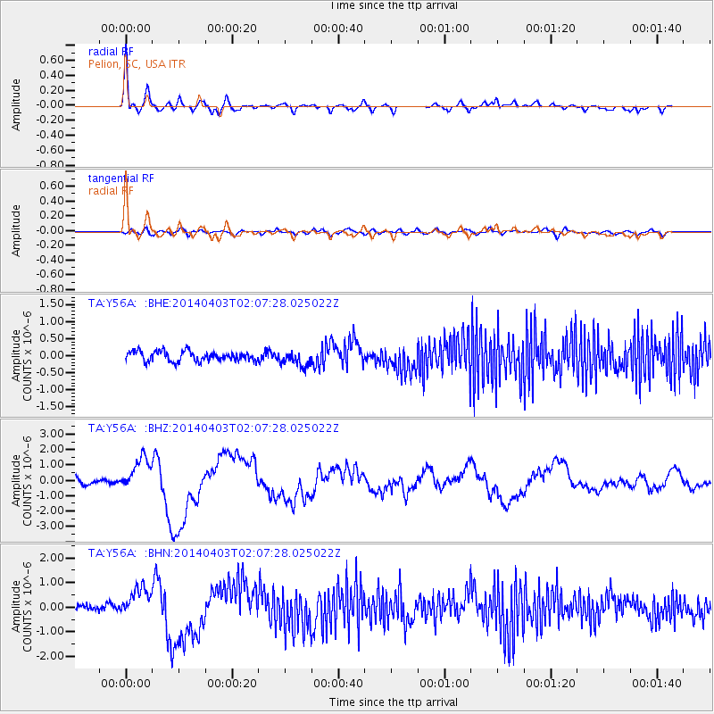
Signal To Noise
| Channel | StoN | STA | LTA |
| TA:Y56A: :BHZ:20140403T02:07:28.025022Z | 7.7525244 | 1.1048033E-6 | 1.4250885E-7 |
| TA:Y56A: :BHN:20140403T02:07:28.025022Z | 2.945334 | 8.102416E-7 | 2.750933E-7 |
| TA:Y56A: :BHE:20140403T02:07:28.025022Z | 1.5590277 | 2.2433204E-7 | 1.4389228E-7 |
| Arrivals |
| Ps | 3.9 SECOND |
| PpPs | 14 SECOND |
| PsPs/PpSs | 18 SECOND |


