You are here: Home > Network List > US - United States National Seismic Network Stations List
> Station EGMT Eagleton, Montana, USA > Earthquake Result Viewer
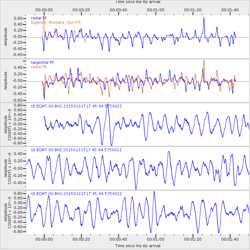
EGMT Eagleton, Montana, USA - Earthquake Result Viewer
*The percent match for this event was below the threshold and hence no stack was calculated.
| Earthquake location: |
Pribilof Islands, Alaska Region |
| Earthquake latitude/longitude: |
56.7/-169.1 |
| Earthquake time(UTC): |
2015/01/31 (031) 17:39:12 GMT |
| Earthquake Depth: |
10 km |
| Earthquake Magnitude: |
5.4 MW, 5.3 mb, 5.0 MS |
| Earthquake Catalog/Contributor: |
ISC/ISC |
|
| Network: |
US United States National Seismic Network |
| Station: |
EGMT Eagleton, Montana, USA |
| Lat/Lon: |
48.02 N/109.75 W |
| Elevation: |
1055 m |
|
| Distance: |
36.2 deg |
| Az: |
77.873 deg |
| Baz: |
306.457 deg |
| Ray Param: |
$rayparam |
*The percent match for this event was below the threshold and hence was not used in the summary stack. |
|
| Radial Match: |
42.6759 % |
| Radial Bump: |
400 |
| Transverse Match: |
60.672894 % |
| Transverse Bump: |
400 |
| SOD ConfigId: |
6954951 |
| Insert Time: |
2019-04-16 07:24:18.589 +0000 |
| GWidth: |
2.5 |
| Max Bumps: |
400 |
| Tol: |
0.001 |
|
Signal To Noise
| Channel | StoN | STA | LTA |
| US:EGMT:00:BHZ:20150131T17:45:44.575002Z | 1.2931155 | 2.5173767E-7 | 1.9467531E-7 |
| US:EGMT:00:BH1:20150131T17:45:44.575002Z | 1.5489047 | 4.500516E-7 | 2.905612E-7 |
| US:EGMT:00:BH2:20150131T17:45:44.575002Z | 3.6143036 | 5.1835417E-7 | 1.4341744E-7 |
| Arrivals |
| Ps | |
| PpPs | |
| PsPs/PpSs | |


