You are here: Home > Network List > WY - Yellowstone Wyoming Seismic Network Stations List
> Station YNR Norris Junction, YNP, WY, USA > Earthquake Result Viewer
YNR Norris Junction, YNP, WY, USA - Earthquake Result Viewer
| Earthquake location: |
Near Coast Of Northern Chile |
| Earthquake latitude/longitude: |
-20.3/-70.6 |
| Earthquake time(UTC): |
2014/04/03 (093) 01:58:31 GMT |
| Earthquake Depth: |
23 km |
| Earthquake Magnitude: |
6.5 MWW, 6.5 MWB, 6.6 MWC |
| Earthquake Catalog/Contributor: |
NEIC PDE/NEIC COMCAT |
|
| Network: |
WY Yellowstone Wyoming Seismic Network |
| Station: |
YNR Norris Junction, YNP, WY, USA |
| Lat/Lon: |
44.72 N/110.68 W |
| Elevation: |
2336 m |
|
| Distance: |
74.3 deg |
| Az: |
331.495 deg |
| Baz: |
141.066 deg |
| Ray Param: |
0.05239114 |
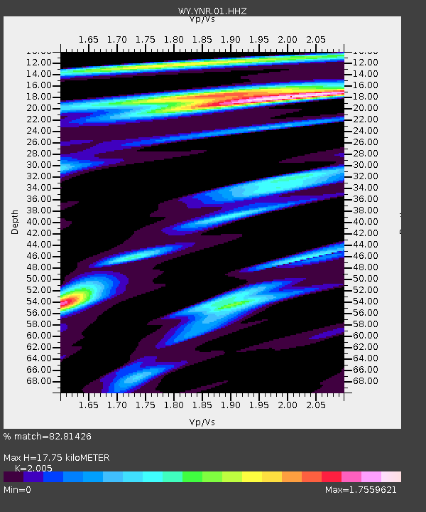
| Estimated Moho Depth: |
17.75 km |
| Estimated Crust Vp/Vs: |
2.01 |
| Assumed Crust Vp: |
6.35 km/s |
| Estimated Crust Vs: |
3.167 km/s |
| Estimated Crust Poisson's Ratio: |
0.33 |
|
| Radial Match: |
82.81426 % |
| Radial Bump: |
400 |
| Transverse Match: |
69.5889 % |
| Transverse Bump: |
400 |
| SOD ConfigId: |
626651 |
| Insert Time: |
2014-04-22 04:16:34.699 +0000 |
| GWidth: |
2.5 |
| Max Bumps: |
400 |
| Tol: |
0.001 |
|
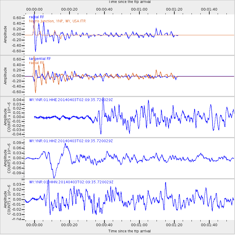
Signal To Noise
| Channel | StoN | STA | LTA |
| WY:YNR:01:HHZ:20140403T02:09:35.720029Z | 3.4598625 | 1.2593185E-8 | 3.6397936E-9 |
| WY:YNR:01:HHN:20140403T02:09:35.720029Z | 0.536877 | 2.919954E-9 | 5.438777E-9 |
| WY:YNR:01:HHE:20140403T02:09:35.720029Z | 3.323353 | 5.7487752E-9 | 1.7298117E-9 |
| Arrivals |
| Ps | 2.9 SECOND |
| PpPs | 8.2 SECOND |
| PsPs/PpSs | 11 SECOND |


