You are here: Home > Network List > II - Global Seismograph Network (GSN - IRIS/IDA) Stations List
> Station FFC Flin Flon, Canada > Earthquake Result Viewer
FFC Flin Flon, Canada - Earthquake Result Viewer
| Earthquake location: |
North Of Honduras |
| Earthquake latitude/longitude: |
16.7/-86.2 |
| Earthquake time(UTC): |
2009/05/28 (148) 08:24:45 GMT |
| Earthquake Depth: |
10 km |
| Earthquake Magnitude: |
6.7 MB, 7.2 MS, 7.3 MW, 7.3 MW |
| Earthquake Catalog/Contributor: |
WHDF/NEIC |
|
| Network: |
II Global Seismograph Network (GSN - IRIS/IDA) |
| Station: |
FFC Flin Flon, Canada |
| Lat/Lon: |
54.72 N/101.98 W |
| Elevation: |
338 m |
|
| Distance: |
39.8 deg |
| Az: |
345.774 deg |
| Baz: |
156.049 deg |
| Ray Param: |
0.074753106 |
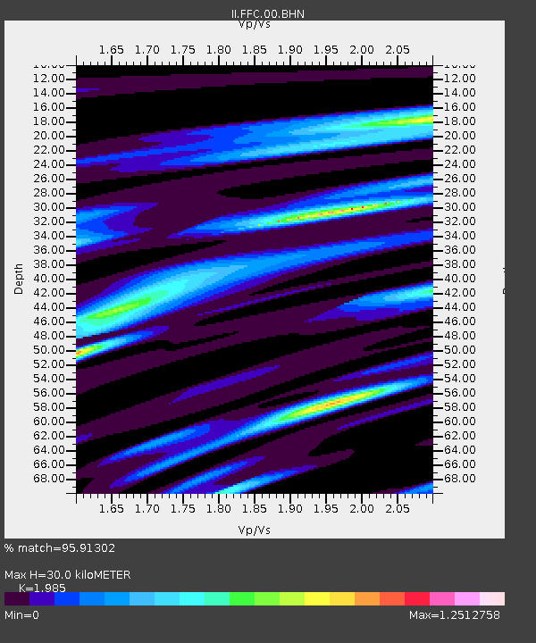
| Estimated Moho Depth: |
30.0 km |
| Estimated Crust Vp/Vs: |
1.99 |
| Assumed Crust Vp: |
6.552 km/s |
| Estimated Crust Vs: |
3.301 km/s |
| Estimated Crust Poisson's Ratio: |
0.33 |
|
| Radial Match: |
95.91302 % |
| Radial Bump: |
269 |
| Transverse Match: |
81.2404 % |
| Transverse Bump: |
400 |
| SOD ConfigId: |
2648 |
| Insert Time: |
2010-03-01 20:08:11.335 +0000 |
| GWidth: |
2.5 |
| Max Bumps: |
400 |
| Tol: |
0.001 |
|
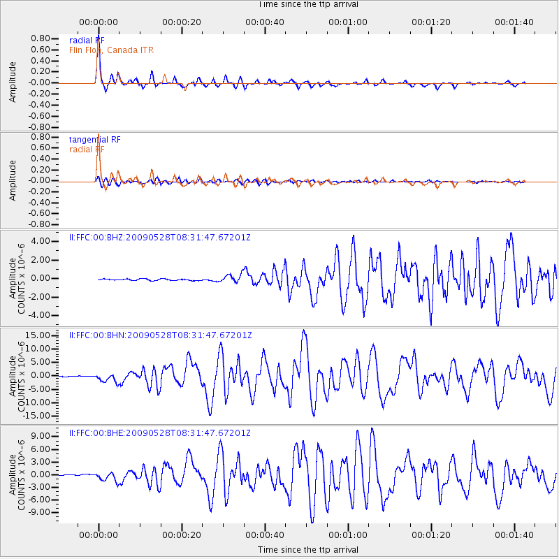
Signal To Noise
| Channel | StoN | STA | LTA |
| II:FFC:00:BHN:20090528T08:31:47.67201Z | 14.851636 | 1.5807009E-6 | 1.0643277E-7 |
| II:FFC:00:BHE:20090528T08:31:47.67201Z | 10.739328 | 1.1022839E-6 | 1.0263992E-7 |
| II:FFC:00:BHZ:20090528T08:31:47.67201Z | 5.4774394 | 4.5239463E-7 | 8.259235E-8 |
| Arrivals |
| Ps | 4.8 SECOND |
| PpPs | 13 SECOND |
| PsPs/PpSs | 18 SECOND |


