You are here: Home > Network List > CU - Caribbean Network (USGS) Stations List
> Station GRTK Grand Turk, Turks and Caicos Islands > Earthquake Result Viewer
GRTK Grand Turk, Turks and Caicos Islands - Earthquake Result Viewer
| Earthquake location: |
Near Coast Of Northern Chile |
| Earthquake latitude/longitude: |
-20.5/-70.5 |
| Earthquake time(UTC): |
2014/04/03 (093) 02:43:14 GMT |
| Earthquake Depth: |
31 km |
| Earthquake Magnitude: |
7.7 MWW, 7.4 MI, 7.7 MWC |
| Earthquake Catalog/Contributor: |
NEIC PDE/NEIC COMCAT |
|
| Network: |
CU Caribbean Network (USGS) |
| Station: |
GRTK Grand Turk, Turks and Caicos Islands |
| Lat/Lon: |
21.51 N/71.13 W |
| Elevation: |
12 m |
|
| Distance: |
41.8 deg |
| Az: |
359.113 deg |
| Baz: |
179.107 deg |
| Ray Param: |
0.07351478 |
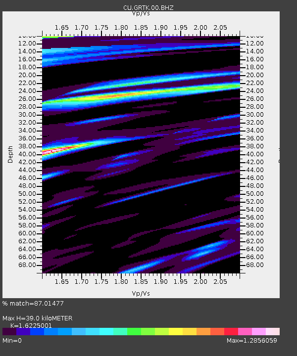
| Estimated Moho Depth: |
39.0 km |
| Estimated Crust Vp/Vs: |
1.62 |
| Assumed Crust Vp: |
4.452 km/s |
| Estimated Crust Vs: |
2.744 km/s |
| Estimated Crust Poisson's Ratio: |
0.19 |
|
| Radial Match: |
87.01477 % |
| Radial Bump: |
358 |
| Transverse Match: |
88.77285 % |
| Transverse Bump: |
400 |
| SOD ConfigId: |
626651 |
| Insert Time: |
2014-04-22 04:25:29.599 +0000 |
| GWidth: |
2.5 |
| Max Bumps: |
400 |
| Tol: |
0.001 |
|

Signal To Noise
| Channel | StoN | STA | LTA |
| CU:GRTK:00:BHZ:20140403T02:50:30.72401Z | 3.8484478 | 4.319192E-6 | 1.1223206E-6 |
| CU:GRTK:00:BH1:20140403T02:50:30.72401Z | 2.4183302 | 2.4261892E-6 | 1.0032497E-6 |
| CU:GRTK:00:BH2:20140403T02:50:30.72401Z | 0.851642 | 1.0115632E-6 | 1.1877798E-6 |
| Arrivals |
| Ps | 5.6 SECOND |
| PpPs | 22 SECOND |
| PsPs/PpSs | 28 SECOND |


