You are here: Home > Network List > LD - Lamont-Doherty Cooperative Seismographic Network Stations List
> Station HBVT Hinesburg, VT > Earthquake Result Viewer
HBVT Hinesburg, VT - Earthquake Result Viewer
| Earthquake location: |
Near Coast Of Northern Chile |
| Earthquake latitude/longitude: |
-20.5/-70.5 |
| Earthquake time(UTC): |
2014/04/03 (093) 02:43:14 GMT |
| Earthquake Depth: |
31 km |
| Earthquake Magnitude: |
7.7 MWW, 7.4 MI, 7.7 MWC |
| Earthquake Catalog/Contributor: |
NEIC PDE/NEIC COMCAT |
|
| Network: |
LD Lamont-Doherty Cooperative Seismographic Network |
| Station: |
HBVT Hinesburg, VT |
| Lat/Lon: |
44.36 N/73.07 W |
| Elevation: |
1130 m |
|
| Distance: |
64.6 deg |
| Az: |
357.962 deg |
| Baz: |
177.336 deg |
| Ray Param: |
0.058767598 |
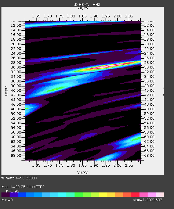
| Estimated Moho Depth: |
29.25 km |
| Estimated Crust Vp/Vs: |
1.96 |
| Assumed Crust Vp: |
6.419 km/s |
| Estimated Crust Vs: |
3.275 km/s |
| Estimated Crust Poisson's Ratio: |
0.32 |
|
| Radial Match: |
98.23087 % |
| Radial Bump: |
237 |
| Transverse Match: |
86.26658 % |
| Transverse Bump: |
400 |
| SOD ConfigId: |
626651 |
| Insert Time: |
2014-04-22 04:31:28.597 +0000 |
| GWidth: |
2.5 |
| Max Bumps: |
400 |
| Tol: |
0.001 |
|

Signal To Noise
| Channel | StoN | STA | LTA |
| LD:HBVT: :HHZ:20140403T02:53:18.285015Z | 3.2682364 | 1.9213326E-6 | 5.8788055E-7 |
| LD:HBVT: :HHN:20140403T02:53:18.285015Z | 1.0906513 | 4.694628E-7 | 4.3044264E-7 |
| LD:HBVT: :HHE:20140403T02:53:18.285015Z | 1.3572711 | 6.74225E-7 | 4.967505E-7 |
| Arrivals |
| Ps | 4.5 SECOND |
| PpPs | 13 SECOND |
| PsPs/PpSs | 18 SECOND |


