You are here: Home > Network List > LD - Lamont-Doherty Cooperative Seismographic Network Stations List
> Station MVL Millersville University, PA > Earthquake Result Viewer
MVL Millersville University, PA - Earthquake Result Viewer
| Earthquake location: |
Near Coast Of Northern Chile |
| Earthquake latitude/longitude: |
-20.5/-70.5 |
| Earthquake time(UTC): |
2014/04/03 (093) 02:43:14 GMT |
| Earthquake Depth: |
31 km |
| Earthquake Magnitude: |
7.7 MWW, 7.4 MI, 7.7 MWC |
| Earthquake Catalog/Contributor: |
NEIC PDE/NEIC COMCAT |
|
| Network: |
LD Lamont-Doherty Cooperative Seismographic Network |
| Station: |
MVL Millersville University, PA |
| Lat/Lon: |
40.00 N/76.35 W |
| Elevation: |
91 m |
|
| Distance: |
60.4 deg |
| Az: |
354.834 deg |
| Baz: |
173.692 deg |
| Ray Param: |
0.061473154 |
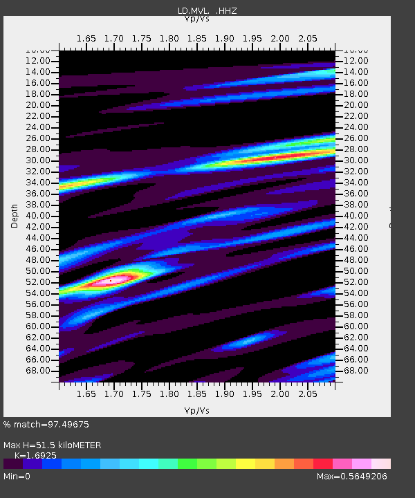
| Estimated Moho Depth: |
51.5 km |
| Estimated Crust Vp/Vs: |
1.69 |
| Assumed Crust Vp: |
6.419 km/s |
| Estimated Crust Vs: |
3.793 km/s |
| Estimated Crust Poisson's Ratio: |
0.23 |
|
| Radial Match: |
97.49675 % |
| Radial Bump: |
225 |
| Transverse Match: |
95.31206 % |
| Transverse Bump: |
362 |
| SOD ConfigId: |
626651 |
| Insert Time: |
2014-04-22 04:31:54.353 +0000 |
| GWidth: |
2.5 |
| Max Bumps: |
400 |
| Tol: |
0.001 |
|

Signal To Noise
| Channel | StoN | STA | LTA |
| LD:MVL: :HHZ:20140403T02:52:50.600017Z | 2.9933784 | 1.2789899E-6 | 4.2727305E-7 |
| LD:MVL: :HHN:20140403T02:52:50.600017Z | 2.1546757 | 1.3087624E-6 | 6.074057E-7 |
| LD:MVL: :HHE:20140403T02:52:50.600017Z | 0.8064994 | 2.1253967E-7 | 2.6353356E-7 |
| Arrivals |
| Ps | 5.8 SECOND |
| PpPs | 21 SECOND |
| PsPs/PpSs | 26 SECOND |


