You are here: Home > Network List > N4 - Central and EAstern US Network Stations List
> Station S44A Carbondale, IL, USA > Earthquake Result Viewer
S44A Carbondale, IL, USA - Earthquake Result Viewer
| Earthquake location: |
Near Coast Of Northern Chile |
| Earthquake latitude/longitude: |
-20.5/-70.5 |
| Earthquake time(UTC): |
2014/04/03 (093) 02:43:14 GMT |
| Earthquake Depth: |
31 km |
| Earthquake Magnitude: |
7.7 MWW, 7.4 MI, 7.7 MWC |
| Earthquake Catalog/Contributor: |
NEIC PDE/NEIC COMCAT |
|
| Network: |
N4 Central and EAstern US Network |
| Station: |
S44A Carbondale, IL, USA |
| Lat/Lon: |
37.69 N/89.26 W |
| Elevation: |
155 m |
|
| Distance: |
60.5 deg |
| Az: |
342.963 deg |
| Baz: |
159.746 deg |
| Ray Param: |
0.061417542 |
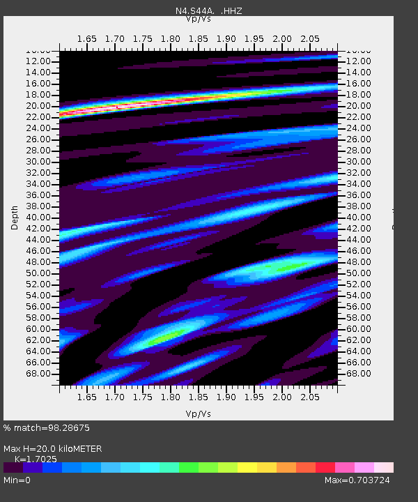
| Estimated Moho Depth: |
20.0 km |
| Estimated Crust Vp/Vs: |
1.70 |
| Assumed Crust Vp: |
6.444 km/s |
| Estimated Crust Vs: |
3.785 km/s |
| Estimated Crust Poisson's Ratio: |
0.24 |
|
| Radial Match: |
98.28675 % |
| Radial Bump: |
298 |
| Transverse Match: |
83.21269 % |
| Transverse Bump: |
400 |
| SOD ConfigId: |
626651 |
| Insert Time: |
2014-04-22 04:35:35.959 +0000 |
| GWidth: |
2.5 |
| Max Bumps: |
400 |
| Tol: |
0.001 |
|

Signal To Noise
| Channel | StoN | STA | LTA |
| N4:S44A: :HHZ:20140403T02:52:51.179973Z | 7.9093504 | 1.8050725E-6 | 2.2822006E-7 |
| N4:S44A: :HHN:20140403T02:52:51.179973Z | 3.3362415 | 1.0251769E-6 | 3.0728498E-7 |
| N4:S44A: :HHE:20140403T02:52:51.179973Z | 1.1581081 | 3.5920104E-7 | 3.1016194E-7 |
| Arrivals |
| Ps | 2.3 SECOND |
| PpPs | 8.0 SECOND |
| PsPs/PpSs | 10 SECOND |


