You are here: Home > Network List > TA - USArray Transportable Network (new EarthScope stations) Stations List
> Station D50A G1974 Best Township, ON, CAN > Earthquake Result Viewer
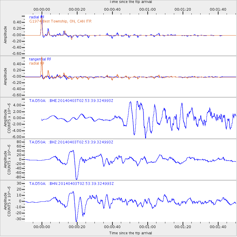
D50A G1974 Best Township, ON, CAN - Earthquake Result Viewer

| Earthquake location: |
Near Coast Of Northern Chile |
| Earthquake latitude/longitude: |
-20.5/-70.5 |
| Earthquake time(UTC): |
2014/04/03 (093) 02:43:14 GMT |
| Earthquake Depth: |
31 km |
| Earthquake Magnitude: |
7.7 MWW, 7.4 MI, 7.7 MWC |
| Earthquake Catalog/Contributor: |
NEIC PDE/NEIC COMCAT |
|
| Network: |
TA USArray Transportable Network (new EarthScope stations) |
| Station: |
D50A G1974 Best Township, ON, CAN |
| Lat/Lon: |
47.17 N/79.84 W |
| Elevation: |
331 m |
|
| Distance: |
67.9 deg |
| Az: |
353.133 deg |
| Baz: |
170.546 deg |
| Ray Param: |
0.056613665 |
| Estimated Moho Depth: |
31.75 km |
| Estimated Crust Vp/Vs: |
1.70 |
| Assumed Crust Vp: |
6.622 km/s |
| Estimated Crust Vs: |
3.895 km/s |
| Estimated Crust Poisson's Ratio: |
0.24 |
|
| Radial Match: |
98.36923 % |
| Radial Bump: |
248 |
| Transverse Match: |
87.15876 % |
| Transverse Bump: |
400 |
| SOD ConfigId: |
626651 |
| Insert Time: |
2014-04-22 04:43:38.337 +0000 |
| GWidth: |
2.5 |
| Max Bumps: |
400 |
| Tol: |
0.001 |
|
Signal To Noise
| Channel | StoN | STA | LTA |
| TA:D50A: :BHZ:20140403T02:53:39.324993Z | 2.5757565 | 2.2244383E-6 | 8.636058E-7 |
| TA:D50A: :BHN:20140403T02:53:39.324993Z | 1.6090356 | 9.615577E-7 | 5.975988E-7 |
| TA:D50A: :BHE:20140403T02:53:39.324993Z | 0.99935246 | 5.851191E-7 | 5.8549824E-7 |
| Arrivals |
| Ps | 3.5 SECOND |
| PpPs | 12 SECOND |
| PsPs/PpSs | 16 SECOND |


