You are here: Home > Network List > TA - USArray Transportable Network (new EarthScope stations) Stations List
> Station E44A Grand Marais Airport, Grand Marais, MI, USA > Earthquake Result Viewer
E44A Grand Marais Airport, Grand Marais, MI, USA - Earthquake Result Viewer
| Earthquake location: |
Near Coast Of Northern Chile |
| Earthquake latitude/longitude: |
-20.5/-70.5 |
| Earthquake time(UTC): |
2014/04/03 (093) 02:43:14 GMT |
| Earthquake Depth: |
31 km |
| Earthquake Magnitude: |
7.7 MWW, 7.4 MI, 7.7 MWC |
| Earthquake Catalog/Contributor: |
NEIC PDE/NEIC COMCAT |
|
| Network: |
TA USArray Transportable Network (new EarthScope stations) |
| Station: |
E44A Grand Marais Airport, Grand Marais, MI, USA |
| Lat/Lon: |
46.62 N/85.92 W |
| Elevation: |
282 m |
|
| Distance: |
68.3 deg |
| Az: |
348.618 deg |
| Baz: |
164.433 deg |
| Ray Param: |
0.056372378 |
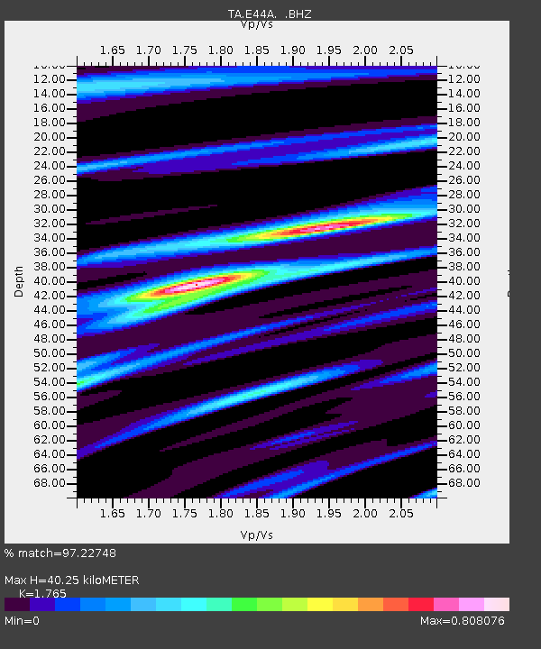
| Estimated Moho Depth: |
40.25 km |
| Estimated Crust Vp/Vs: |
1.76 |
| Assumed Crust Vp: |
6.467 km/s |
| Estimated Crust Vs: |
3.664 km/s |
| Estimated Crust Poisson's Ratio: |
0.26 |
|
| Radial Match: |
97.22748 % |
| Radial Bump: |
391 |
| Transverse Match: |
93.45438 % |
| Transverse Bump: |
400 |
| SOD ConfigId: |
626651 |
| Insert Time: |
2014-04-22 04:44:14.473 +0000 |
| GWidth: |
2.5 |
| Max Bumps: |
400 |
| Tol: |
0.001 |
|
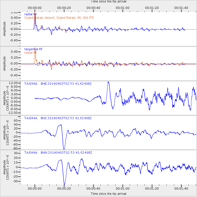
Signal To Noise
| Channel | StoN | STA | LTA |
| TA:E44A: :BHZ:20140403T02:53:41.62498Z | 4.0517125 | 1.7099152E-6 | 4.2202285E-7 |
| TA:E44A: :BHN:20140403T02:53:41.62498Z | 1.7267472 | 1.0970351E-6 | 6.353189E-7 |
| TA:E44A: :BHE:20140403T02:53:41.62498Z | 1.1049418 | 5.067204E-7 | 4.5859463E-7 |
| Arrivals |
| Ps | 5.0 SECOND |
| PpPs | 17 SECOND |
| PsPs/PpSs | 21 SECOND |


