You are here: Home > Network List > TA - USArray Transportable Network (new EarthScope stations) Stations List
> Station G47A Hillman, MI, USA > Earthquake Result Viewer
G47A Hillman, MI, USA - Earthquake Result Viewer
| Earthquake location: |
Near Coast Of Northern Chile |
| Earthquake latitude/longitude: |
-20.5/-70.5 |
| Earthquake time(UTC): |
2014/04/03 (093) 02:43:14 GMT |
| Earthquake Depth: |
31 km |
| Earthquake Magnitude: |
7.7 MWW, 7.4 MI, 7.7 MWC |
| Earthquake Catalog/Contributor: |
NEIC PDE/NEIC COMCAT |
|
| Network: |
TA USArray Transportable Network (new EarthScope stations) |
| Station: |
G47A Hillman, MI, USA |
| Lat/Lon: |
45.17 N/83.86 W |
| Elevation: |
239 m |
|
| Distance: |
66.5 deg |
| Az: |
349.735 deg |
| Baz: |
166.342 deg |
| Ray Param: |
0.05752871 |
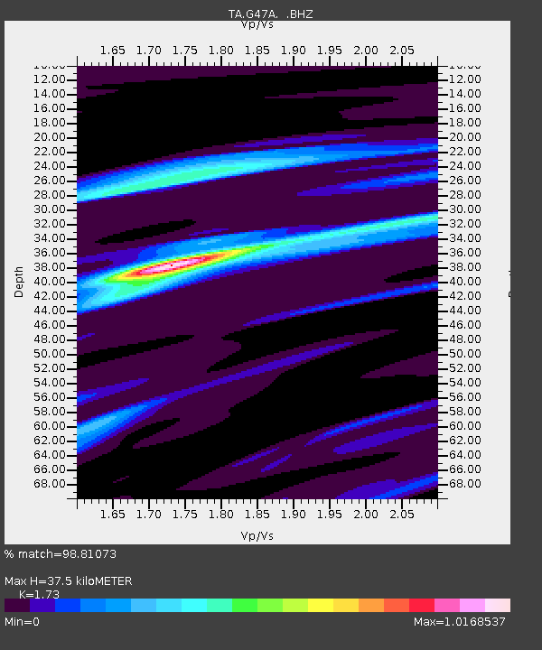
| Estimated Moho Depth: |
37.5 km |
| Estimated Crust Vp/Vs: |
1.73 |
| Assumed Crust Vp: |
6.483 km/s |
| Estimated Crust Vs: |
3.747 km/s |
| Estimated Crust Poisson's Ratio: |
0.25 |
|
| Radial Match: |
98.81073 % |
| Radial Bump: |
200 |
| Transverse Match: |
95.493065 % |
| Transverse Bump: |
341 |
| SOD ConfigId: |
626651 |
| Insert Time: |
2014-04-22 04:45:49.271 +0000 |
| GWidth: |
2.5 |
| Max Bumps: |
400 |
| Tol: |
0.001 |
|

Signal To Noise
| Channel | StoN | STA | LTA |
| TA:G47A: :BHZ:20140403T02:53:30.49998Z | 4.8907223 | 2.7343144E-6 | 5.5908197E-7 |
| TA:G47A: :BHN:20140403T02:53:30.49998Z | 1.9592295 | 9.0141754E-7 | 4.6008776E-7 |
| TA:G47A: :BHE:20140403T02:53:30.49998Z | 1.4111602 | 5.217709E-7 | 3.6974603E-7 |
| Arrivals |
| Ps | 4.4 SECOND |
| PpPs | 15 SECOND |
| PsPs/PpSs | 20 SECOND |


