You are here: Home > Network List > TA - USArray Transportable Network (new EarthScope stations) Stations List
> Station G46A Petoskey, MI, USA > Earthquake Result Viewer
G46A Petoskey, MI, USA - Earthquake Result Viewer
| Earthquake location: |
Near Coast Of Northern Chile |
| Earthquake latitude/longitude: |
-20.5/-70.5 |
| Earthquake time(UTC): |
2014/04/03 (093) 02:43:14 GMT |
| Earthquake Depth: |
31 km |
| Earthquake Magnitude: |
7.7 MWW, 7.4 MI, 7.7 MWC |
| Earthquake Catalog/Contributor: |
NEIC PDE/NEIC COMCAT |
|
| Network: |
TA USArray Transportable Network (new EarthScope stations) |
| Station: |
G46A Petoskey, MI, USA |
| Lat/Lon: |
45.32 N/84.86 W |
| Elevation: |
239 m |
|
| Distance: |
66.8 deg |
| Az: |
349.023 deg |
| Baz: |
165.347 deg |
| Ray Param: |
0.057319485 |
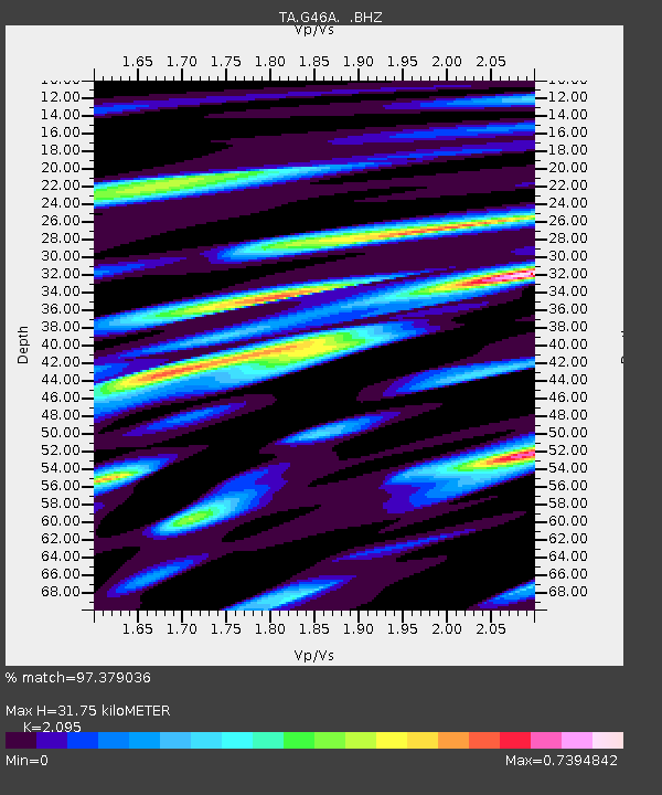
| Estimated Moho Depth: |
31.75 km |
| Estimated Crust Vp/Vs: |
2.10 |
| Assumed Crust Vp: |
6.483 km/s |
| Estimated Crust Vs: |
3.094 km/s |
| Estimated Crust Poisson's Ratio: |
0.35 |
|
| Radial Match: |
97.379036 % |
| Radial Bump: |
390 |
| Transverse Match: |
92.55261 % |
| Transverse Bump: |
400 |
| SOD ConfigId: |
626651 |
| Insert Time: |
2014-04-22 04:45:49.699 +0000 |
| GWidth: |
2.5 |
| Max Bumps: |
400 |
| Tol: |
0.001 |
|

Signal To Noise
| Channel | StoN | STA | LTA |
| TA:G46A: :BHZ:20140403T02:53:32.49998Z | 5.883476 | 2.9424575E-6 | 5.001223E-7 |
| TA:G46A: :BHN:20140403T02:53:32.49998Z | 1.6753428 | 9.3364457E-7 | 5.5728566E-7 |
| TA:G46A: :BHE:20140403T02:53:32.49998Z | 1.2843193 | 7.146276E-7 | 5.564252E-7 |
| Arrivals |
| Ps | 5.6 SECOND |
| PpPs | 15 SECOND |
| PsPs/PpSs | 20 SECOND |


