You are here: Home > Network List > TA - USArray Transportable Network (new EarthScope stations) Stations List
> Station H66A Whiting, ME, USA > Earthquake Result Viewer
H66A Whiting, ME, USA - Earthquake Result Viewer
| Earthquake location: |
Near Coast Of Northern Chile |
| Earthquake latitude/longitude: |
-20.5/-70.5 |
| Earthquake time(UTC): |
2014/04/03 (093) 02:43:14 GMT |
| Earthquake Depth: |
31 km |
| Earthquake Magnitude: |
7.7 MWW, 7.4 MI, 7.7 MWC |
| Earthquake Catalog/Contributor: |
NEIC PDE/NEIC COMCAT |
|
| Network: |
TA USArray Transportable Network (new EarthScope stations) |
| Station: |
H66A Whiting, ME, USA |
| Lat/Lon: |
44.79 N/67.31 W |
| Elevation: |
55 m |
|
| Distance: |
65.1 deg |
| Az: |
2.502 deg |
| Baz: |
183.294 deg |
| Ray Param: |
0.05847766 |
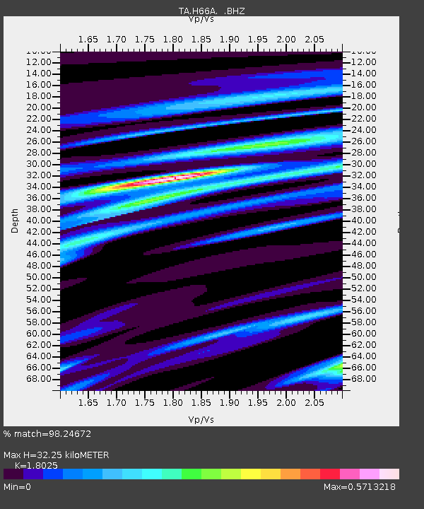
| Estimated Moho Depth: |
32.25 km |
| Estimated Crust Vp/Vs: |
1.80 |
| Assumed Crust Vp: |
6.419 km/s |
| Estimated Crust Vs: |
3.561 km/s |
| Estimated Crust Poisson's Ratio: |
0.28 |
|
| Radial Match: |
98.24672 % |
| Radial Bump: |
273 |
| Transverse Match: |
92.751526 % |
| Transverse Bump: |
400 |
| SOD ConfigId: |
626651 |
| Insert Time: |
2014-04-22 04:47:14.100 +0000 |
| GWidth: |
2.5 |
| Max Bumps: |
400 |
| Tol: |
0.001 |
|

Signal To Noise
| Channel | StoN | STA | LTA |
| TA:H66A: :BHZ:20140403T02:53:21.199016Z | 4.4520073 | 1.6312088E-6 | 3.663985E-7 |
| TA:H66A: :BHN:20140403T02:53:21.199016Z | 1.4221691 | 7.8739754E-7 | 5.5365956E-7 |
| TA:H66A: :BHE:20140403T02:53:21.199016Z | 0.7168816 | 2.7550948E-7 | 3.8431656E-7 |
| Arrivals |
| Ps | 4.2 SECOND |
| PpPs | 14 SECOND |
| PsPs/PpSs | 18 SECOND |


