You are here: Home > Network List > TA - USArray Transportable Network (new EarthScope stations) Stations List
> Station I61A Oroboro, Fairlee, VT, USA > Earthquake Result Viewer
I61A Oroboro, Fairlee, VT, USA - Earthquake Result Viewer
| Earthquake location: |
Near Coast Of Northern Chile |
| Earthquake latitude/longitude: |
-20.5/-70.5 |
| Earthquake time(UTC): |
2014/04/03 (093) 02:43:14 GMT |
| Earthquake Depth: |
31 km |
| Earthquake Magnitude: |
7.7 MWW, 7.4 MI, 7.7 MWC |
| Earthquake Catalog/Contributor: |
NEIC PDE/NEIC COMCAT |
|
| Network: |
TA USArray Transportable Network (new EarthScope stations) |
| Station: |
I61A Oroboro, Fairlee, VT, USA |
| Lat/Lon: |
43.93 N/72.21 W |
| Elevation: |
287 m |
|
| Distance: |
64.2 deg |
| Az: |
358.627 deg |
| Baz: |
178.218 deg |
| Ray Param: |
0.059058342 |
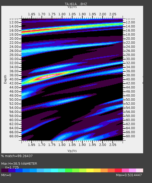
| Estimated Moho Depth: |
38.5 km |
| Estimated Crust Vp/Vs: |
1.73 |
| Assumed Crust Vp: |
6.419 km/s |
| Estimated Crust Vs: |
3.721 km/s |
| Estimated Crust Poisson's Ratio: |
0.25 |
|
| Radial Match: |
99.26437 % |
| Radial Bump: |
229 |
| Transverse Match: |
94.90392 % |
| Transverse Bump: |
400 |
| SOD ConfigId: |
626651 |
| Insert Time: |
2014-04-22 04:48:01.999 +0000 |
| GWidth: |
2.5 |
| Max Bumps: |
400 |
| Tol: |
0.001 |
|

Signal To Noise
| Channel | StoN | STA | LTA |
| TA:I61A: :BHZ:20140403T02:53:15.324993Z | 3.4769137 | 1.3605626E-6 | 3.9131334E-7 |
| TA:I61A: :BHN:20140403T02:53:15.324993Z | 1.7004619 | 7.058511E-7 | 4.1509375E-7 |
| TA:I61A: :BHE:20140403T02:53:15.324993Z | 1.246793 | 4.707325E-7 | 3.7755464E-7 |
| Arrivals |
| Ps | 4.5 SECOND |
| PpPs | 16 SECOND |
| PsPs/PpSs | 20 SECOND |


