You are here: Home > Network List > TA - USArray Transportable Network (new EarthScope stations) Stations List
> Station J61A Chester, VT, USA > Earthquake Result Viewer
J61A Chester, VT, USA - Earthquake Result Viewer
| Earthquake location: |
Near Coast Of Northern Chile |
| Earthquake latitude/longitude: |
-20.5/-70.5 |
| Earthquake time(UTC): |
2014/04/03 (093) 02:43:14 GMT |
| Earthquake Depth: |
31 km |
| Earthquake Magnitude: |
7.7 MWW, 7.4 MI, 7.7 MWC |
| Earthquake Catalog/Contributor: |
NEIC PDE/NEIC COMCAT |
|
| Network: |
TA USArray Transportable Network (new EarthScope stations) |
| Station: |
J61A Chester, VT, USA |
| Lat/Lon: |
43.35 N/72.55 W |
| Elevation: |
253 m |
|
| Distance: |
63.6 deg |
| Az: |
358.326 deg |
| Baz: |
177.848 deg |
| Ray Param: |
0.059439953 |
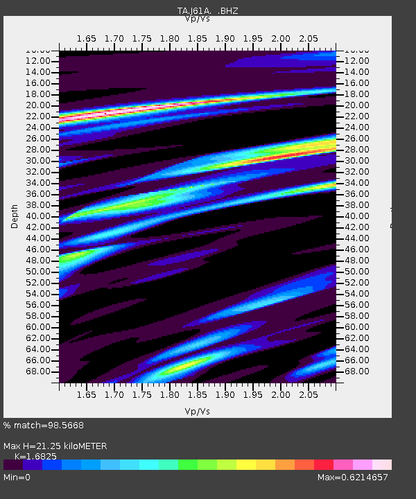
| Estimated Moho Depth: |
21.25 km |
| Estimated Crust Vp/Vs: |
1.68 |
| Assumed Crust Vp: |
6.419 km/s |
| Estimated Crust Vs: |
3.815 km/s |
| Estimated Crust Poisson's Ratio: |
0.23 |
|
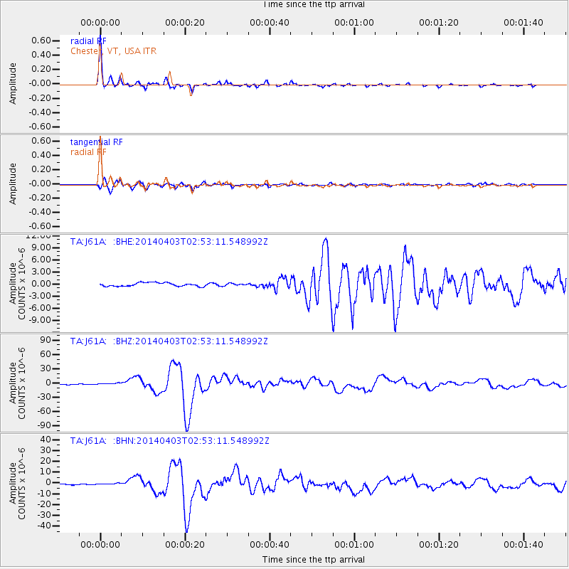
| Radial Match: |
98.5668 % |
| Radial Bump: |
273 |
| Transverse Match: |
94.51536 % |
| Transverse Bump: |
400 |
| SOD ConfigId: |
626651 |
| Insert Time: |
2014-04-22 04:48:55.773 +0000 |
| GWidth: |
2.5 |
| Max Bumps: |
400 |
| Tol: |
0.001 |
|
Signal To Noise
| Channel | StoN | STA | LTA |
| TA:J61A: :BHZ:20140403T02:53:11.548992Z | 2.1338284 | 1.560729E-6 | 7.3142195E-7 |
| TA:J61A: :BHN:20140403T02:53:11.548992Z | 1.1568291 | 6.8795987E-7 | 5.946945E-7 |
| TA:J61A: :BHE:20140403T02:53:11.548992Z | 0.5600982 | 2.4580947E-7 | 4.3886854E-7 |
| Arrivals |
| Ps | 2.4 SECOND |
| PpPs | 8.5 SECOND |
| PsPs/PpSs | 11 SECOND |


