You are here: Home > Network List > TA - USArray Transportable Network (new EarthScope stations) Stations List
> Station J63A Strafford, NH, USA > Earthquake Result Viewer
J63A Strafford, NH, USA - Earthquake Result Viewer
| Earthquake location: |
Near Coast Of Northern Chile |
| Earthquake latitude/longitude: |
-20.5/-70.5 |
| Earthquake time(UTC): |
2014/04/03 (093) 02:43:14 GMT |
| Earthquake Depth: |
31 km |
| Earthquake Magnitude: |
7.7 MWW, 7.4 MI, 7.7 MWC |
| Earthquake Catalog/Contributor: |
NEIC PDE/NEIC COMCAT |
|
| Network: |
TA USArray Transportable Network (new EarthScope stations) |
| Station: |
J63A Strafford, NH, USA |
| Lat/Lon: |
43.28 N/71.08 W |
| Elevation: |
142 m |
|
| Distance: |
63.5 deg |
| Az: |
359.526 deg |
| Baz: |
179.392 deg |
| Ray Param: |
0.05950004 |
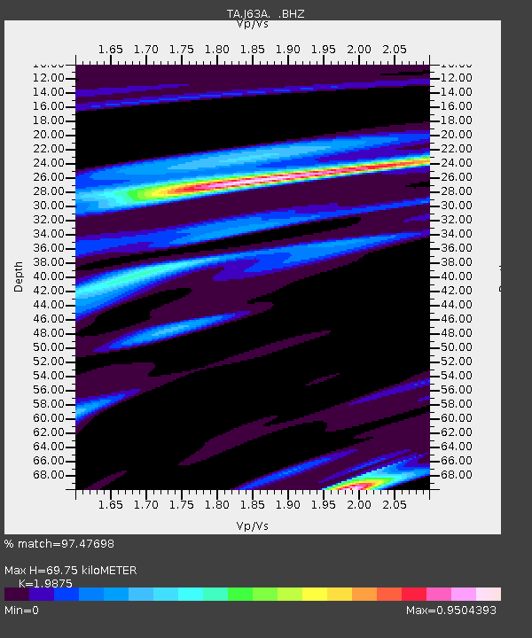
| Estimated Moho Depth: |
69.75 km |
| Estimated Crust Vp/Vs: |
1.99 |
| Assumed Crust Vp: |
6.419 km/s |
| Estimated Crust Vs: |
3.23 km/s |
| Estimated Crust Poisson's Ratio: |
0.33 |
|
| Radial Match: |
97.47698 % |
| Radial Bump: |
360 |
| Transverse Match: |
93.051765 % |
| Transverse Bump: |
400 |
| SOD ConfigId: |
626651 |
| Insert Time: |
2014-04-22 04:49:06.047 +0000 |
| GWidth: |
2.5 |
| Max Bumps: |
400 |
| Tol: |
0.001 |
|

Signal To Noise
| Channel | StoN | STA | LTA |
| TA:J63A: :BHZ:20140403T02:53:10.925029Z | 2.1795685 | 1.5746397E-6 | 7.2245473E-7 |
| TA:J63A: :BHN:20140403T02:53:10.925029Z | 1.0876646 | 5.221305E-7 | 4.8004733E-7 |
| TA:J63A: :BHE:20140403T02:53:10.925029Z | 0.9238609 | 4.0702946E-7 | 4.405744E-7 |
| Arrivals |
| Ps | 11 SECOND |
| PpPs | 31 SECOND |
| PsPs/PpSs | 42 SECOND |


