You are here: Home > Network List > TA - USArray Transportable Network (new EarthScope stations) Stations List
> Station K46A Dorr, MI, USA > Earthquake Result Viewer
K46A Dorr, MI, USA - Earthquake Result Viewer
| Earthquake location: |
Near Coast Of Northern Chile |
| Earthquake latitude/longitude: |
-20.5/-70.5 |
| Earthquake time(UTC): |
2014/04/03 (093) 02:43:14 GMT |
| Earthquake Depth: |
31 km |
| Earthquake Magnitude: |
7.7 MWW, 7.4 MI, 7.7 MWC |
| Earthquake Catalog/Contributor: |
NEIC PDE/NEIC COMCAT |
|
| Network: |
TA USArray Transportable Network (new EarthScope stations) |
| Station: |
K46A Dorr, MI, USA |
| Lat/Lon: |
42.69 N/85.78 W |
| Elevation: |
213 m |
|
| Distance: |
64.4 deg |
| Az: |
347.558 deg |
| Baz: |
164.104 deg |
| Ray Param: |
0.05886672 |
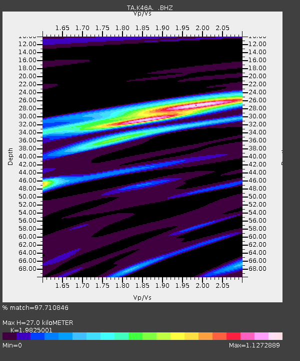
| Estimated Moho Depth: |
27.0 km |
| Estimated Crust Vp/Vs: |
1.98 |
| Assumed Crust Vp: |
6.483 km/s |
| Estimated Crust Vs: |
3.27 km/s |
| Estimated Crust Poisson's Ratio: |
0.33 |
|
| Radial Match: |
97.710846 % |
| Radial Bump: |
311 |
| Transverse Match: |
92.13342 % |
| Transverse Bump: |
400 |
| SOD ConfigId: |
626651 |
| Insert Time: |
2014-04-22 04:49:29.635 +0000 |
| GWidth: |
2.5 |
| Max Bumps: |
400 |
| Tol: |
0.001 |
|

Signal To Noise
| Channel | StoN | STA | LTA |
| TA:K46A: :BHZ:20140403T02:53:17.275005Z | 12.738775 | 3.5334938E-6 | 2.7738096E-7 |
| TA:K46A: :BHN:20140403T02:53:17.275005Z | 2.6877518 | 1.7180625E-6 | 6.3921925E-7 |
| TA:K46A: :BHE:20140403T02:53:17.275005Z | 1.8755614 | 9.653253E-7 | 5.1468606E-7 |
| Arrivals |
| Ps | 4.3 SECOND |
| PpPs | 12 SECOND |
| PsPs/PpSs | 16 SECOND |


