You are here: Home > Network List > TA - USArray Transportable Network (new EarthScope stations) Stations List
> Station L46A Eue Claire, MI, USA > Earthquake Result Viewer
L46A Eue Claire, MI, USA - Earthquake Result Viewer
| Earthquake location: |
Near Coast Of Northern Chile |
| Earthquake latitude/longitude: |
-20.5/-70.5 |
| Earthquake time(UTC): |
2014/04/03 (093) 02:43:14 GMT |
| Earthquake Depth: |
31 km |
| Earthquake Magnitude: |
7.7 MWW, 7.4 MI, 7.7 MWC |
| Earthquake Catalog/Contributor: |
NEIC PDE/NEIC COMCAT |
|
| Network: |
TA USArray Transportable Network (new EarthScope stations) |
| Station: |
L46A Eue Claire, MI, USA |
| Lat/Lon: |
42.01 N/86.30 W |
| Elevation: |
223 m |
|
| Distance: |
63.9 deg |
| Az: |
346.944 deg |
| Baz: |
163.493 deg |
| Ray Param: |
0.05921882 |
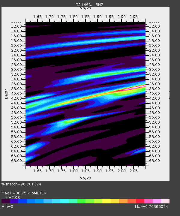
| Estimated Moho Depth: |
36.75 km |
| Estimated Crust Vp/Vs: |
2.08 |
| Assumed Crust Vp: |
6.483 km/s |
| Estimated Crust Vs: |
3.117 km/s |
| Estimated Crust Poisson's Ratio: |
0.35 |
|
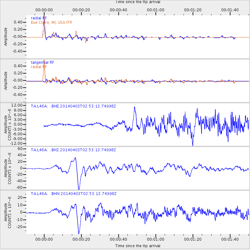
| Radial Match: |
96.701324 % |
| Radial Bump: |
286 |
| Transverse Match: |
89.905 % |
| Transverse Bump: |
400 |
| SOD ConfigId: |
626651 |
| Insert Time: |
2014-04-22 04:50:38.905 +0000 |
| GWidth: |
2.5 |
| Max Bumps: |
400 |
| Tol: |
0.001 |
|
Signal To Noise
| Channel | StoN | STA | LTA |
| TA:L46A: :BHZ:20140403T02:53:13.74998Z | 5.3969984 | 2.3585183E-6 | 4.3700555E-7 |
| TA:L46A: :BHN:20140403T02:53:13.74998Z | 4.4132786 | 1.6461111E-6 | 3.7299054E-7 |
| TA:L46A: :BHE:20140403T02:53:13.74998Z | 1.9693487 | 8.7939856E-7 | 4.4654283E-7 |
| Arrivals |
| Ps | 6.4 SECOND |
| PpPs | 17 SECOND |
| PsPs/PpSs | 23 SECOND |


