You are here: Home > Network List > US - United States National Seismic Network Stations List
> Station MSO Missoula, Montana, USA > Earthquake Result Viewer
MSO Missoula, Montana, USA - Earthquake Result Viewer
*The percent match for this event was below the threshold and hence no stack was calculated.
| Earthquake location: |
South Of Panama |
| Earthquake latitude/longitude: |
7.7/-82.9 |
| Earthquake time(UTC): |
2015/01/31 (031) 18:55:43 GMT |
| Earthquake Depth: |
9.1 km |
| Earthquake Magnitude: |
5.2 MW, 4.7 mb, 4.6 MS |
| Earthquake Catalog/Contributor: |
ISC/ISC |
|
| Network: |
US United States National Seismic Network |
| Station: |
MSO Missoula, Montana, USA |
| Lat/Lon: |
46.83 N/113.94 W |
| Elevation: |
1264 m |
|
| Distance: |
47.1 deg |
| Az: |
331.12 deg |
| Baz: |
135.805 deg |
| Ray Param: |
$rayparam |
*The percent match for this event was below the threshold and hence was not used in the summary stack. |
|
| Radial Match: |
64.662605 % |
| Radial Bump: |
400 |
| Transverse Match: |
77.728516 % |
| Transverse Bump: |
297 |
| SOD ConfigId: |
6962031 |
| Insert Time: |
2019-04-16 08:01:28.153 +0000 |
| GWidth: |
2.5 |
| Max Bumps: |
400 |
| Tol: |
0.001 |
|
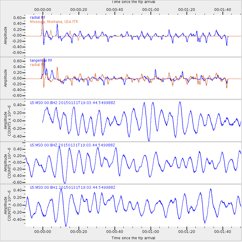
Signal To Noise
| Channel | StoN | STA | LTA |
| US:MSO:00:BHZ:20150131T19:03:44.549988Z | 0.9768582 | 1.8417039E-7 | 1.8853339E-7 |
| US:MSO:00:BH1:20150131T19:03:44.549988Z | 0.97063535 | 2.2462808E-7 | 2.3142375E-7 |
| US:MSO:00:BH2:20150131T19:03:44.549988Z | 1.1601979 | 2.3727412E-7 | 2.0451178E-7 |
| Arrivals |
| Ps | |
| PpPs | |
| PsPs/PpSs | |


