You are here: Home > Network List > TA - USArray Transportable Network (new EarthScope stations) Stations List
> Station M49A Liberty Center, OH, USA > Earthquake Result Viewer
M49A Liberty Center, OH, USA - Earthquake Result Viewer
| Earthquake location: |
Near Coast Of Northern Chile |
| Earthquake latitude/longitude: |
-20.5/-70.5 |
| Earthquake time(UTC): |
2014/04/03 (093) 02:43:14 GMT |
| Earthquake Depth: |
31 km |
| Earthquake Magnitude: |
7.7 MWW, 7.4 MI, 7.7 MWC |
| Earthquake Catalog/Contributor: |
NEIC PDE/NEIC COMCAT |
|
| Network: |
TA USArray Transportable Network (new EarthScope stations) |
| Station: |
M49A Liberty Center, OH, USA |
| Lat/Lon: |
41.47 N/83.98 W |
| Elevation: |
203 m |
|
| Distance: |
62.9 deg |
| Az: |
348.657 deg |
| Baz: |
165.799 deg |
| Ray Param: |
0.05985624 |
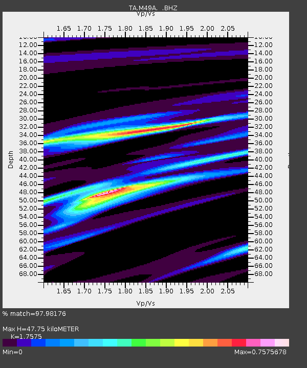
| Estimated Moho Depth: |
47.75 km |
| Estimated Crust Vp/Vs: |
1.76 |
| Assumed Crust Vp: |
6.498 km/s |
| Estimated Crust Vs: |
3.697 km/s |
| Estimated Crust Poisson's Ratio: |
0.26 |
|
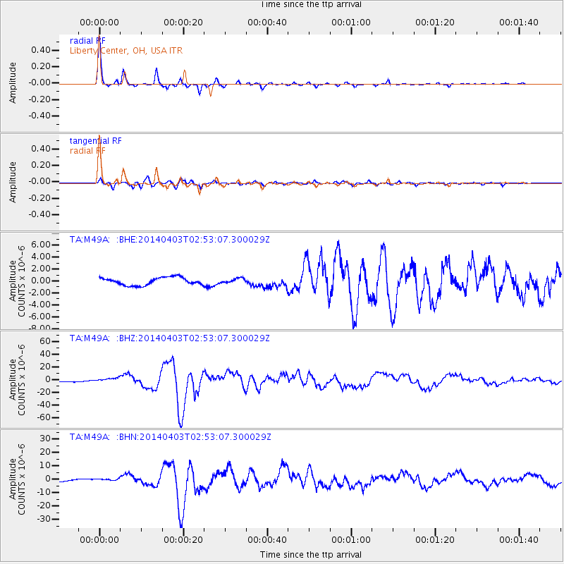
| Radial Match: |
97.98176 % |
| Radial Bump: |
163 |
| Transverse Match: |
94.8139 % |
| Transverse Bump: |
343 |
| SOD ConfigId: |
626651 |
| Insert Time: |
2014-04-22 04:51:35.848 +0000 |
| GWidth: |
2.5 |
| Max Bumps: |
400 |
| Tol: |
0.001 |
|
Signal To Noise
| Channel | StoN | STA | LTA |
| TA:M49A: :BHZ:20140403T02:53:07.300029Z | 3.1864343 | 3.412459E-6 | 1.0709334E-6 |
| TA:M49A: :BHN:20140403T02:53:07.300029Z | 1.3109015 | 8.5352525E-7 | 6.5109793E-7 |
| TA:M49A: :BHE:20140403T02:53:07.300029Z | 0.6136995 | 3.9309964E-7 | 6.405409E-7 |
| Arrivals |
| Ps | 5.8 SECOND |
| PpPs | 19 SECOND |
| PsPs/PpSs | 25 SECOND |


