You are here: Home > Network List > TA - USArray Transportable Network (new EarthScope stations) Stations List
> Station M60A Port Jervis, NY, USA > Earthquake Result Viewer
M60A Port Jervis, NY, USA - Earthquake Result Viewer
| Earthquake location: |
Near Coast Of Northern Chile |
| Earthquake latitude/longitude: |
-20.5/-70.5 |
| Earthquake time(UTC): |
2014/04/03 (093) 02:43:14 GMT |
| Earthquake Depth: |
31 km |
| Earthquake Magnitude: |
7.7 MWW, 7.4 MI, 7.7 MWC |
| Earthquake Catalog/Contributor: |
NEIC PDE/NEIC COMCAT |
|
| Network: |
TA USArray Transportable Network (new EarthScope stations) |
| Station: |
M60A Port Jervis, NY, USA |
| Lat/Lon: |
41.33 N/74.62 W |
| Elevation: |
292 m |
|
| Distance: |
61.6 deg |
| Az: |
356.469 deg |
| Baz: |
175.604 deg |
| Ray Param: |
0.06069177 |
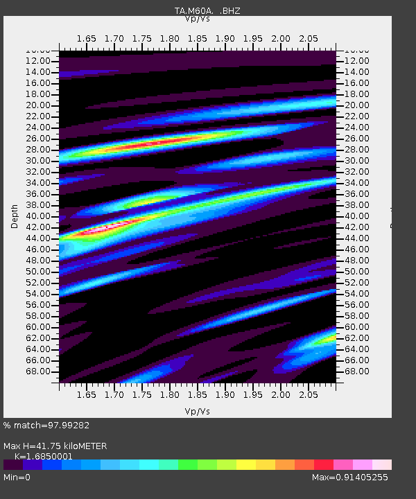
| Estimated Moho Depth: |
41.75 km |
| Estimated Crust Vp/Vs: |
1.69 |
| Assumed Crust Vp: |
6.283 km/s |
| Estimated Crust Vs: |
3.729 km/s |
| Estimated Crust Poisson's Ratio: |
0.23 |
|
| Radial Match: |
97.99282 % |
| Radial Bump: |
290 |
| Transverse Match: |
88.11681 % |
| Transverse Bump: |
400 |
| SOD ConfigId: |
626651 |
| Insert Time: |
2014-04-22 04:52:07.992 +0000 |
| GWidth: |
2.5 |
| Max Bumps: |
400 |
| Tol: |
0.001 |
|

Signal To Noise
| Channel | StoN | STA | LTA |
| TA:M60A: :BHZ:20140403T02:52:58.725017Z | 4.3665514 | 1.7788161E-6 | 4.073732E-7 |
| TA:M60A: :BHN:20140403T02:52:58.725017Z | 1.9027432 | 5.5325756E-7 | 2.9076838E-7 |
| TA:M60A: :BHE:20140403T02:52:58.725017Z | 1.1394119 | 6.7056163E-7 | 5.885156E-7 |
| Arrivals |
| Ps | 4.8 SECOND |
| PpPs | 17 SECOND |
| PsPs/PpSs | 22 SECOND |


