You are here: Home > Network List > TA - USArray Transportable Network (new EarthScope stations) Stations List
> Station P51A Williamsport, OH, USA > Earthquake Result Viewer
P51A Williamsport, OH, USA - Earthquake Result Viewer
| Earthquake location: |
Near Coast Of Northern Chile |
| Earthquake latitude/longitude: |
-20.5/-70.5 |
| Earthquake time(UTC): |
2014/04/03 (093) 02:43:14 GMT |
| Earthquake Depth: |
31 km |
| Earthquake Magnitude: |
7.7 MWW, 7.4 MI, 7.7 MWC |
| Earthquake Catalog/Contributor: |
NEIC PDE/NEIC COMCAT |
|
| Network: |
TA USArray Transportable Network (new EarthScope stations) |
| Station: |
P51A Williamsport, OH, USA |
| Lat/Lon: |
39.48 N/83.06 W |
| Elevation: |
211 m |
|
| Distance: |
60.8 deg |
| Az: |
348.885 deg |
| Baz: |
166.498 deg |
| Ray Param: |
0.061220992 |
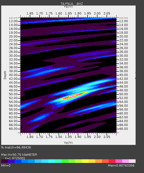
| Estimated Moho Depth: |
50.75 km |
| Estimated Crust Vp/Vs: |
1.87 |
| Assumed Crust Vp: |
6.232 km/s |
| Estimated Crust Vs: |
3.328 km/s |
| Estimated Crust Poisson's Ratio: |
0.30 |
|
| Radial Match: |
96.49438 % |
| Radial Bump: |
249 |
| Transverse Match: |
90.78182 % |
| Transverse Bump: |
400 |
| SOD ConfigId: |
626651 |
| Insert Time: |
2014-04-22 04:54:25.904 +0000 |
| GWidth: |
2.5 |
| Max Bumps: |
400 |
| Tol: |
0.001 |
|

Signal To Noise
| Channel | StoN | STA | LTA |
| TA:P51A: :BHZ:20140403T02:52:53.199993Z | 1.3007656 | 1.2169467E-6 | 9.355618E-7 |
| TA:P51A: :BHN:20140403T02:52:53.199993Z | 2.4052322 | 1.0139859E-6 | 4.2157507E-7 |
| TA:P51A: :BHE:20140403T02:52:53.199993Z | 1.2972319 | 7.2150937E-7 | 5.5619154E-7 |
| Arrivals |
| Ps | 7.4 SECOND |
| PpPs | 22 SECOND |
| PsPs/PpSs | 30 SECOND |


