You are here: Home > Network List > TA - USArray Transportable Network (new EarthScope stations) Stations List
> Station R56A Bull Pasture Mountain, McDowell, VA, USA > Earthquake Result Viewer
R56A Bull Pasture Mountain, McDowell, VA, USA - Earthquake Result Viewer
| Earthquake location: |
Near Coast Of Northern Chile |
| Earthquake latitude/longitude: |
-20.5/-70.5 |
| Earthquake time(UTC): |
2014/04/03 (093) 02:43:14 GMT |
| Earthquake Depth: |
31 km |
| Earthquake Magnitude: |
7.7 MWW, 7.4 MI, 7.7 MWC |
| Earthquake Catalog/Contributor: |
NEIC PDE/NEIC COMCAT |
|
| Network: |
TA USArray Transportable Network (new EarthScope stations) |
| Station: |
R56A Bull Pasture Mountain, McDowell, VA, USA |
| Lat/Lon: |
38.41 N/79.40 W |
| Elevation: |
902 m |
|
| Distance: |
59.2 deg |
| Az: |
351.861 deg |
| Baz: |
170.275 deg |
| Ray Param: |
0.0622894 |
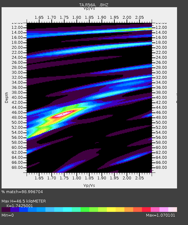
| Estimated Moho Depth: |
46.5 km |
| Estimated Crust Vp/Vs: |
1.74 |
| Assumed Crust Vp: |
6.159 km/s |
| Estimated Crust Vs: |
3.534 km/s |
| Estimated Crust Poisson's Ratio: |
0.25 |
|
| Radial Match: |
98.996704 % |
| Radial Bump: |
201 |
| Transverse Match: |
93.501625 % |
| Transverse Bump: |
400 |
| SOD ConfigId: |
626651 |
| Insert Time: |
2014-04-22 04:56:17.882 +0000 |
| GWidth: |
2.5 |
| Max Bumps: |
400 |
| Tol: |
0.001 |
|
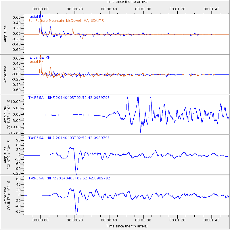
Signal To Noise
| Channel | StoN | STA | LTA |
| TA:R56A: :BHZ:20140403T02:52:42.098979Z | 2.530111 | 1.3757508E-6 | 5.437511E-7 |
| TA:R56A: :BHN:20140403T02:52:42.098979Z | 1.6213212 | 7.3753887E-7 | 4.5489992E-7 |
| TA:R56A: :BHE:20140403T02:52:42.098979Z | 1.7346139 | 3.1321457E-7 | 1.805673E-7 |
| Arrivals |
| Ps | 5.9 SECOND |
| PpPs | 20 SECOND |
| PsPs/PpSs | 26 SECOND |


