You are here: Home > Network List > TA - USArray Transportable Network (new EarthScope stations) Stations List
> Station S51A Beattyville, KY, USA > Earthquake Result Viewer
S51A Beattyville, KY, USA - Earthquake Result Viewer
| Earthquake location: |
Near Coast Of Northern Chile |
| Earthquake latitude/longitude: |
-20.5/-70.5 |
| Earthquake time(UTC): |
2014/04/03 (093) 02:43:14 GMT |
| Earthquake Depth: |
31 km |
| Earthquake Magnitude: |
7.7 MWW, 7.4 MI, 7.7 MWC |
| Earthquake Catalog/Contributor: |
NEIC PDE/NEIC COMCAT |
|
| Network: |
TA USArray Transportable Network (new EarthScope stations) |
| Station: |
S51A Beattyville, KY, USA |
| Lat/Lon: |
37.64 N/83.59 W |
| Elevation: |
286 m |
|
| Distance: |
59.1 deg |
| Az: |
347.906 deg |
| Baz: |
165.677 deg |
| Ray Param: |
0.062329125 |
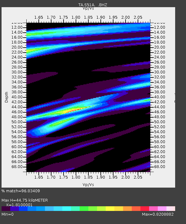
| Estimated Moho Depth: |
44.75 km |
| Estimated Crust Vp/Vs: |
1.81 |
| Assumed Crust Vp: |
6.476 km/s |
| Estimated Crust Vs: |
3.578 km/s |
| Estimated Crust Poisson's Ratio: |
0.28 |
|
| Radial Match: |
96.83409 % |
| Radial Bump: |
314 |
| Transverse Match: |
87.96943 % |
| Transverse Bump: |
400 |
| SOD ConfigId: |
626651 |
| Insert Time: |
2014-04-22 04:56:38.244 +0000 |
| GWidth: |
2.5 |
| Max Bumps: |
400 |
| Tol: |
0.001 |
|
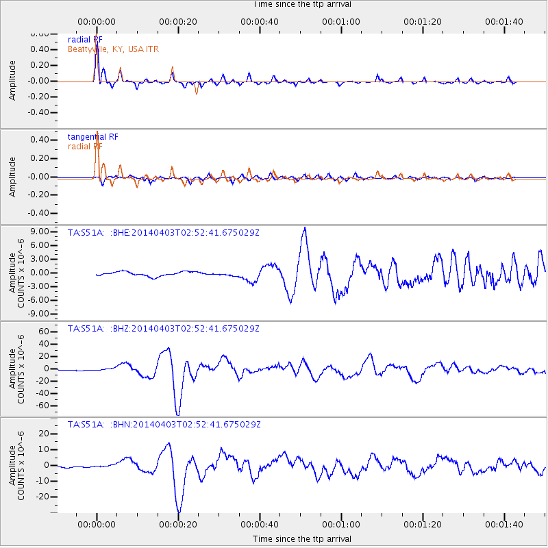
Signal To Noise
| Channel | StoN | STA | LTA |
| TA:S51A: :BHZ:20140403T02:52:41.675029Z | 3.483863 | 2.0411849E-6 | 5.85897E-7 |
| TA:S51A: :BHN:20140403T02:52:41.675029Z | 1.5971363 | 7.9345125E-7 | 4.9679625E-7 |
| TA:S51A: :BHE:20140403T02:52:41.675029Z | 0.78595203 | 3.69233E-7 | 4.6979073E-7 |
| Arrivals |
| Ps | 5.9 SECOND |
| PpPs | 19 SECOND |
| PsPs/PpSs | 24 SECOND |


