You are here: Home > Network List > TA - USArray Transportable Network (new EarthScope stations) Stations List
> Station S53A Williamson, WV, USA > Earthquake Result Viewer
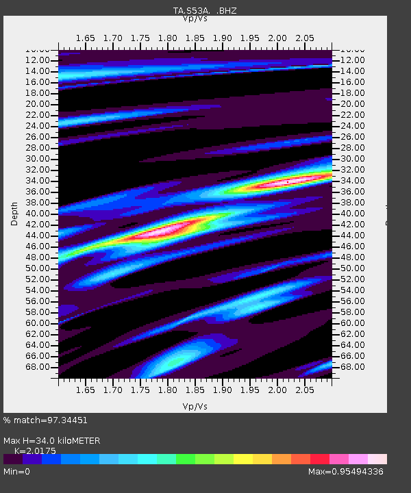
S53A Williamson, WV, USA - Earthquake Result Viewer
| Earthquake location: |
Near Coast Of Northern Chile |
| Earthquake latitude/longitude: |
-20.5/-70.5 |
| Earthquake time(UTC): |
2014/04/03 (093) 02:43:14 GMT |
| Earthquake Depth: |
31 km |
| Earthquake Magnitude: |
7.7 MWW, 7.4 MI, 7.7 MWC |
| Earthquake Catalog/Contributor: |
NEIC PDE/NEIC COMCAT |
|
| Network: |
TA USArray Transportable Network (new EarthScope stations) |
| Station: |
S53A Williamson, WV, USA |
| Lat/Lon: |
37.68 N/82.13 W |
| Elevation: |
564 m |
|
| Distance: |
58.9 deg |
| Az: |
349.237 deg |
| Baz: |
167.255 deg |
| Ray Param: |
0.06248187 |
| Estimated Moho Depth: |
34.0 km |
| Estimated Crust Vp/Vs: |
2.02 |
| Assumed Crust Vp: |
6.476 km/s |
| Estimated Crust Vs: |
3.21 km/s |
| Estimated Crust Poisson's Ratio: |
0.34 |
|
| Radial Match: |
97.34451 % |
| Radial Bump: |
292 |
| Transverse Match: |
92.216644 % |
| Transverse Bump: |
400 |
| SOD ConfigId: |
626651 |
| Insert Time: |
2014-04-22 04:56:43.875 +0000 |
| GWidth: |
2.5 |
| Max Bumps: |
400 |
| Tol: |
0.001 |
|

Signal To Noise
| Channel | StoN | STA | LTA |
| TA:S53A: :BHZ:20140403T02:52:40.074993Z | 5.0119452 | 2.1444778E-6 | 4.2787335E-7 |
| TA:S53A: :BHN:20140403T02:52:40.074993Z | 2.6553648 | 1.2561094E-6 | 4.730459E-7 |
| TA:S53A: :BHE:20140403T02:52:40.074993Z | 1.734706 | 4.7430476E-7 | 2.7342082E-7 |
| Arrivals |
| Ps | 5.6 SECOND |
| PpPs | 15 SECOND |
| PsPs/PpSs | 21 SECOND |


